
Framing Silver’s Void in Timothy H. O’Sullivan’s Photographs of the Gould & Curry Mine
PDF: Garnier, Framing Silver’s Void
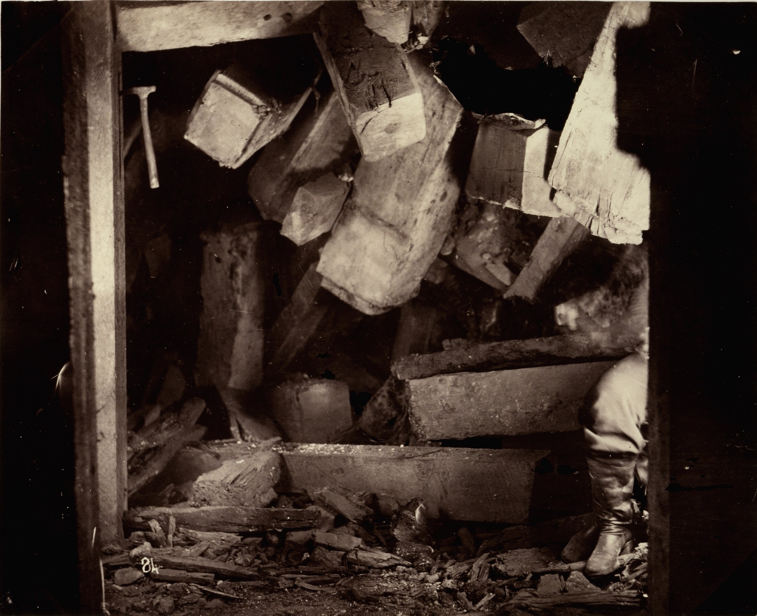
In his groundbreaking novel Roughing It, the American satirist Mark Twain described the silver mines of the Comstock Lode in Virginia City, Nevada, as “clean-picked ribs and bones of some colossal skeleton” and “a coffin that has no end to it.”1 As the center of the silver mining industry in the United States, Virginia City was the product of hundreds of miles of underground tunnels created for the extraction of precious metal. These mines became an international sensation in the late nineteenth century because of the “unlimited” or “inexhaustible” silver they provided not only for currency but also for dining services, jewelry, and photography. A photograph formed from silver, Crushed Timbers (fig. 1) shifts focus away from the sensational ore to tell a darker story about the timber “ribs and bones” that held open the subterranean spaces in the ore’s absence. Ends of squared timbers jut into the frame from above, dominating the upper half of the composition. Strong light from both sides creates extreme shadows, sharpening the angularity of the beams while also abstracting the wooden surfaces. A small pickax is driven into a structural beam in the upper left corner, while a worker’s leg uncomfortably protrudes into the scene at lower right, his body dramatically cut by a vertical support cast entirely in shadow. These compositional elements compress the photographic frame to produce a sense of claustrophobia, almost as if to entomb its contents. And yet, the focus on timber over silver suggests entanglements with the surface above.
Timothy H. O’Sullivan (c. 1840−1882) created Crushed Timbers during his tenure as the photographer for the geological exploration of the fortieth parallel under the direction of Clarence King (1842−1901). The team’s goal was to document a vast portion of the Great Basin, carefully mapping elevations for the transcontinental railroad while collecting mineral and botanical specimens throughout California, Nevada, and the Utah Territory. Often relying on local Numu (Northern Paiute) and Shoshone guides, the survey team gathered data on the landscape and extractive industries in the region and developed strategies that could help “produce the largest yield of the precious metals” in the world.2 After starting the project during the summer of 1867, the survey team wintered between Carson City and Virginia City to study the working mines of the Comstock Lode. Uncovered by Henry Comstock in 1859, this series of silver veins running through Mount Davidson became the new epicenter of mining within the United States following the California Gold Rush of the 1850s and the Pyramid Lake War of 1860. Yet production had slowed toward 1867. During their winter stay, the survey team completed their first written report on the mining industry under the direction of engineer James D. Hague (1836−1909). Titled “Mining Industry,” this report would help geologists, industrialists, and investors link horizontal studies of the Earth’s surface, made visible through mapping rock formations like quartzite, with vertical stratigraphic reports on the potential ore underneath.3 Crushed Timbers, along with O’Sullivan’s other subterranean photographs, were excluded from the final report.
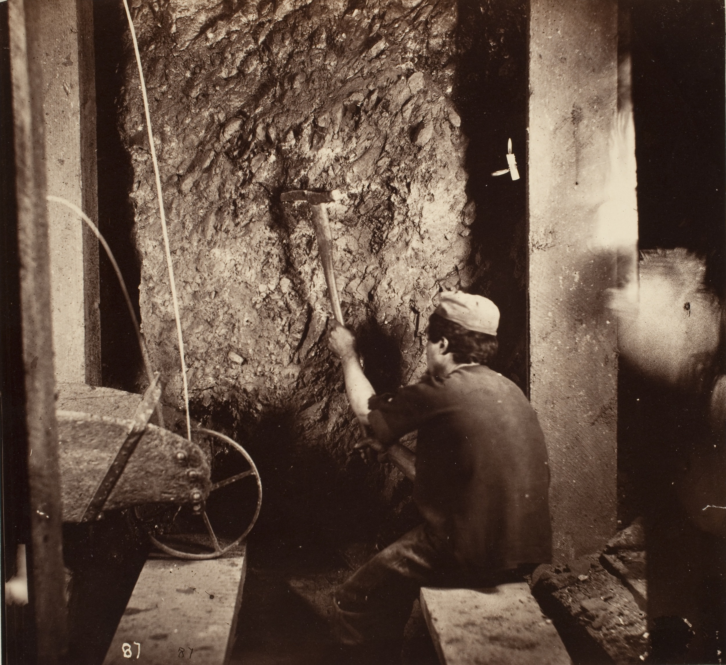
Unlike the iconic landscape views O’Sullivan captured from the King and later Wheeler surveys during the 1870s, art historians often analyze these subterranean photographs as oddities. One of the more studied images from this series is Worker, Gould & Curry Mill (fig. 2), which situates a laborer at the center of the photographic frame. He is in control of his tools and directly engages with argentiferous rock outcroppings that one would expect to find in a mine. Because this series does not clearly depict mining machinery, Alan Trachtenberg hypothesizes that King excluded underground images in his sycophantic report of the mining industry’s technological advancements.4 In turn, Keith Davis argues that the subterranean photographs are more about labor than geology because the images fail to capture the same rich description of minerals as found in the rest of O’Sullivan’s landscape surface photographs. Davis observes that the tight spaces of the mine’s tunnels likely dictated the photographer’s subject matter: “As a result of this severely constrained angle of view, most of these images are jammed with discordant, ambiguous information. In part for this reason, these views emphasize people more than process.”5 Miner and pickax are framed at the center of the composition in Worker, Gould & Curry Mill to provide an essentialist vision of mining labor instead of highlighting the innovative machinery celebrated by engineers across the globe during this time.
Robin Kelsey posits O’Sullivan’s subterranean mining images as a critical intervention in the history of photography by centering the material importance of silver for the industry. Kelsey interprets O’Sullivan’s under-published photographs as a type of gangue—the excess quartz-rock or vein-stuff that encases silver and is discarded in the extraction process. Such a material parallel also reveals a different relation between miner and photographer: “A miner works the surface of a silver mine, while behind him the photographer works the surface of his silvered photographic plate. To illuminate the rocky surface, the miner uses a candle; to illuminate the scene, the photographer uses a magnesium flash, two sparks of which have left trains on the left side of the image.”6 Indeed, mining photographs do help reframe photography’s visual prioritization of human subject over material substrate.7 Yet, if art historians continue to take up the call and consider this medium’s material underpinnings, should our analysis stop at the elemental in the bottom of a silver mine? What other social and ecological networks are represented in O’Sullivan’s photographs of the silver mine beyond ore and the miner?
As a mysterious outlier in an already small corpus of subterranean images, O’Sullivan’s Crushed Timbers invites exploration of silver’s “negative ecologies,” namely the ecological contingencies of the silver mine disrupted by extraction, revealing other histories of environmental injustice and slow violence that often fall outside the photographic frame.8 Instead of centering the relation between silver ore and its transformation into silver nitrate for the photographic industry, Crushed Timbers refocuses the camera’s gaze on wood. O’Sullivan displaces body and tool to the periphery in favor of heavy, square timbers that jut and push into the central space of the frame. Subject becomes frame; frame becomes subject. How might this reframing in Crushed Timbers point to networks of labor and land that exceed the miner’s body and the mine? In what way does wood tie together issues of a predominantly Euro-American mining industry with issues of land seizure, local foodways, and Indigenous sovereignty around the area of the Comstock Lode?
O’Sullivan brought the material realities of timber to the foreground in Crushed Timbers at a moment when the mining industry’s demands on the environment reached a critical point, as local Numu and Washoe leaders publicly emphasized. To center the environmental and human networks entwined with these wooden beams, I focus on how the wooden grid visible in O’Sullivan’s images operated as a critical framing device for engineering, cartography, and photography. I then follow the impacts of deforestation that came at the expense of silver’s extraction, ultimately reinterpreting the space of the mine as a set of ecological contingencies. This angle reveals how the silver mining industry participated in the collapse of local foodways and subsequent displacement of Numu and Washoe communities in the area. Overall, I argue that O’Sullivan’s Crushed Timbers visually reconfigures industry rhetoric about the nation’s “inexhaustible” metallic resources, subliminally foregrounding Indigenous anxieties over the emergence of silver’s negative ecologies on the Comstock Lode.
Framing Inexhaustible Silver
O’Sullivan’s task to capture the Gould & Curry mines was part of King’s efforts to visualize the seemingly limitless silver ore of the Comstock and argue for more industrial capital, materials, and labor to extract it. Throughout the 1860s, scientists and industrialists drew upon the emerging geological theory of catastrophism to characterize the Comstock veins as inexhaustible. Catastrophism was a school of thought that characterized the development of the Earth’s crust through uneven periods of violence and rupture, including the sudden compression and cooling of molten mineral sludge to form rich metallic veins beneath the Earth’s surface. This countered previous scientific theories of slow, even, and unmotivated geological development. Cataclysmic moments provided evidence of “telluric energy,” which propelled transformations to shape the advancement of “civilization,” including the development of metallic veins.9 As mining was a primary driver of US colonization of the Intermountain West, geology became a critical tool not only for expanding scientific knowledge but also for expanding industry for the nation’s economy following the debts accrued during the Civil War. O’Sullivan’s subterranean photographs reveal how colonization encompassed spaces deep under the land’s surface.
Once-molten flows from the center of the Earth, the notorious argentiferous veins of the Comstock Lode came to be seen as potentially unending. A year before King’s survey began, an unnamed author in the trade magazine Mining News published an article that tried to articulate the causal relationship between catastrophism and inexhaustibility. Because “metallic veins are the fillings of fissures” of the Earth’s crust, then “they must be inexhaustible, for it extends from the surface to the regions of fire beneath.” Evidence of continuity would be key. The writer continued to claim that of all the active mines throughout the globe, “not one of these veins . . . has the features of continuity more strangely marked than the Comstock Lode, and few of them promise to yield more silver.”10 The question was not whether silver ore existed and in what quantity but how to access, extract, and process it. According to another journalist writing in the same periodical only months before, the nation needed the “strong arms of Capital and Labor to bring [silver] to light and to convert it into the means of wealth and prosperity never yet excelled in the history of the world.”11 While the US Congress passed the Mineral Resources Act in 1866 to open public lands for prospecting and infrastructure development, accurate geological knowledge about these mineral regions remained lacking. In response, King lobbied Congress for a complete geological survey of the fortieth parallel in 1867 to analyze and document the geographical landscape of Nevada and Utah that encompassed the mining district around Virginia City.
King employed photography as an experimental medium to visualize these geological histories alongside maps and specimen descriptions. Earlier in April 1867, the chief engineer of the US Army, General Andrew A. Humphreys, directed King to give his “personal attention to the photographic apparatus” in his investigations of the Great Basin starting that year.12 Despite King’s preference for his friend Carleton Watkins (1829−1916), who was already in the field for a survey in California, O’Sullivan was hired as the sole photographer of the expedition due to his previous experience with the US Army. O’Sullivan probably trained with Mathew Brady in New York and then worked for Alexander Gardner in Washington, DC, through the Civil War. Identified as an author of many photographs in Gardner’s Photographic Sketchbook of the Civil War (1865−1866), O’Sullivan had an established reputation for documentary photography in the nation’s capital.13 Humphreys likely recommended the photographer to King because he was well known among topographical engineers in the department.
O’Sullivan was tasked with documenting everything from specific rock formations to broad mountainous vistas during his commission, which ran from April 1867 through September 1869. Jason Weems argues that King’s surveying mechanisms appear latent in O’Sullivan’s photographs, all of which supported the goal of connecting landscape features with the invisible treasures that lay beneath.14 The study of strata, or the Earth’s layers, could be key to new discoveries based on close study of certain samples. The Comstock Lode, one of the most developed mining areas in the United States at the time, operated as a test case for linking King’s cartographic maps with stratigraphic assumptions.
O’Sullivan carried his stereo camera into the depths of the Gould & Curry mine alongside survey geologists in February 1868 to visualize this speculative connection between mapping the landscape above and documenting the veins below. O’Sullivan may have chosen to use his stereo camera from his photographic kit for practical reasons.15 Doubling the image, the camera harshly cropped the constricted space of the mine to mimic the vertical and horizontal wooden structures that enclose these subterranean tableaux. The photographer illuminated these underground spaces with magnesium flashes as other members of the team collected measurements and rock samples.16 These flashes transform the rock wall into a glistening surface in Worker, Gould & Curry Mill (see fig. 2). His back to the camera, this unidentified worker is conspicuously seated with legs dangling down between the two beams that make up a floor. The miner’s pick seems to locate a center, not for the photographic image but for the timbers that frame the space, creating a structural cube around the figure. As the rock wall at center makes the cube’s furthest face, the picture plane completes the parallel side due to the rectangular cropping of the camera. While the miner operates as the central element of the image, the timber framing reveals the internal mechanics of the photographic crop, standardizing spatial relations in an otherwise illegible space. In the original stereo-negative, this image would have been doubled, accentuating the presence of vertical and horizontal timbers.
A more complex framing is found in Miners at Work Underground, Virginia City (fig. 3), which also reveals additional cropping in the printing of images for stereo cards. Crouched down against a rock wall, a miner holds his pickax while posing in profile for O’Sullivan’s camera. His body is framed by a subtle post-and-lintel archway of timbers in the background, holding open the space to a chamber beyond. Dangling precariously to the right is a large timber that becomes an internal framing device. The scale of this timber overwhelms the miner, almost acting as a second body in the image. Due to deformations in the silver gelatin around the edges of the image, additional cropping was needed to clean up the shot. Shown in red, this cropping reinforced the internal architectural elements, which are further stressed when the image is doubled in the assembly of a stereo card for its limited circulation among personal acquaintances of the survey team or through special geological commissions.17 The image posits formal tensions between the internal frames created by human-made structures underground and the external frame imposed by the camera and the finishing crop.18
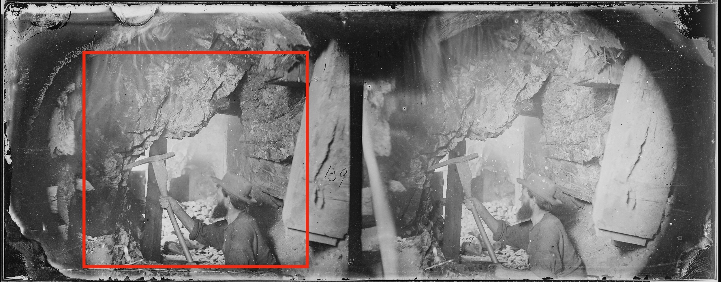
This framing recalls Rosalind E. Krauss’s analysis of the modern grid—a system of logic that extends in all directions and signals art as a fragment of nature. Characterized as a crop or tear from nature, the photograph operates as part of this logical system, and yet the doubling of the grid in O’Sullivan’s stereographic negatives unconsciously signals a larger structure beyond the photographic frame. Here I propose a “centrifugal reading,” what Krauss defines as a reading “outward, compelling our acknowledgment of a world beyond the frame.”19 Through the doubling of the frame—the wooden structure of the mine and the external crop of the camera—each subterranean print gestures toward a larger grid network that formed the architecture of the Comstock’s silver mines. O’Sullivan’s play with framing is not purely formal but highlights the most important technological invention of the Comstock and one focus of King and Hague’s report—the square-set timbering method.
Organizing Silver’s Extractive Grid
The cartographic grid is hidden in plain sight in O’Sullivan’s subterranean photographs by way of these square-set timbers, the iconic engineering innovation developed for the US mining industry. The grid came to structure not only the unwieldy veins of the Comstock Lode but the entire enterprise of Virginia City as a town dependent upon mining. In November 1860, Director W. F. Babcock of the Ophir Mining Company hired the twenty-eight-year-old German engineer Philip Deidesheimer (1832−1916) to devise a support solution for working quartz lodes over sixty feet in width, the largest silver vein ever confronted by the industry. The request came at the close of the Pyramid Lake War, a conflict ignited by organized miners in the region to intimidate local Numu and Washoe Peoples while seizing land for industry development.20 Deidesheimer previously studied at the famous Freiberg University of Mining in Germany before emigrating to the United States in 1851 at the height of the Gold Rush to work veins in the county of El Dorado, California. Babcock convinced the engineer to come to Virginia City by noting that “unless some method of preventing the ground from caving were discovered, [the rich lode] must be abandoned, notwithstanding its enormous value.”21 Success on the Comstock was already framed as a problem of technical agility in relation to its latent, inexhaustible wealth.
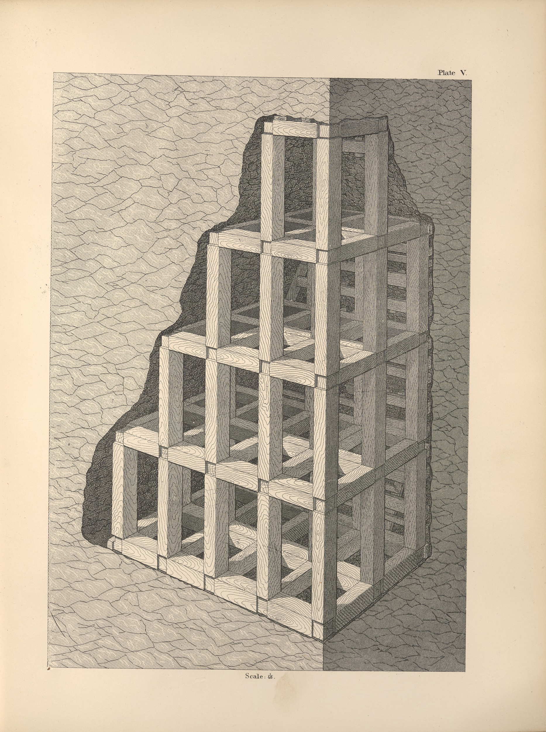
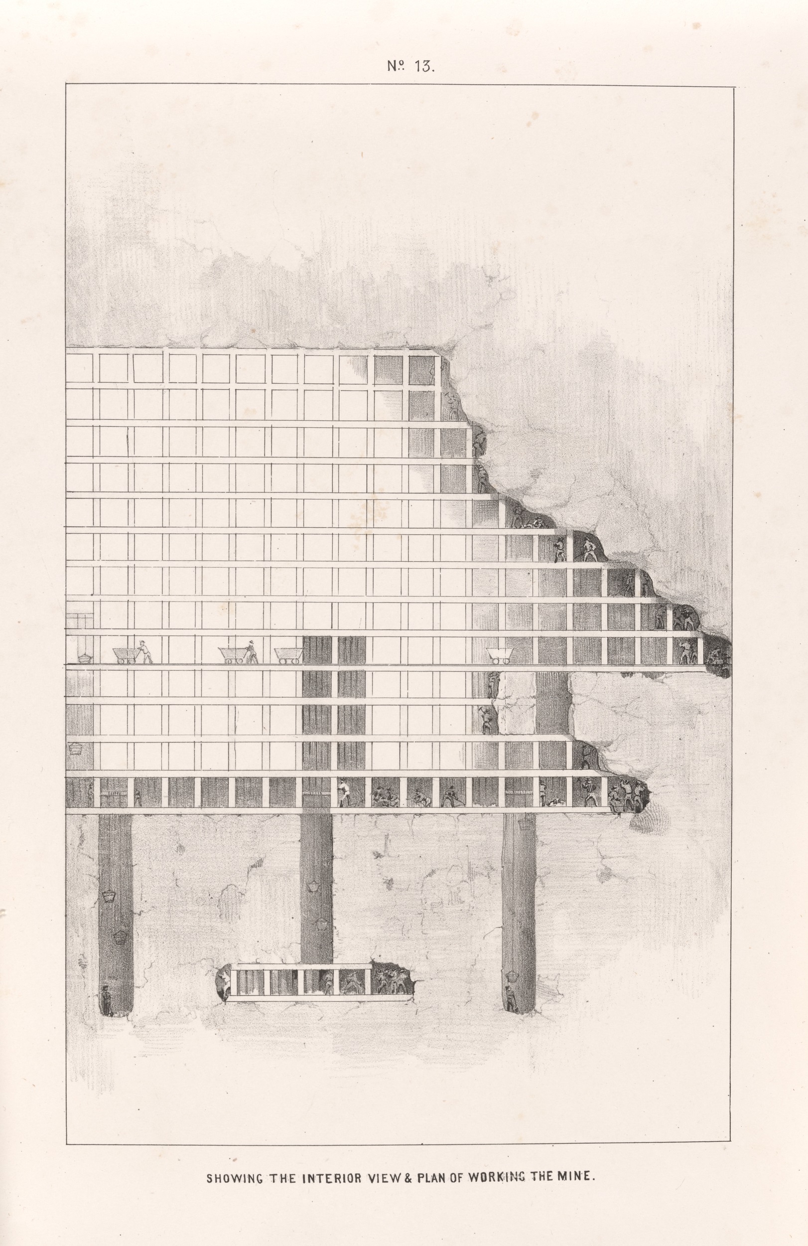
Deidesheimer proposed the construction of an innovative bracing system that translated the cryptic physics of structural pressure into a visible problem of geometry. To illustrate this innovation, King and Hague included an engineering diagram of Deidesheimer’s square-set structure within their volume (fig. 4). Lumber was cut into square beams between six and eight feet in length, which were then braced together at the ends to create a honeycomb architecture. A system of cubes could be tailored to the space of the mine, following the natural turns of a metallic vein while redistributing the pressure of the earth. When reflecting on this system years later, Deidesheimer emphasized its spatial flexibility, noting that silver ore could be safely extracted at “any height, or any width, or any length, or any depth.”22 In other words, mining was a problem of scale, not material reality. Manifest through timbered supports, Deidesheimer’s method would elevate Virginia City in the eyes of engineering academics within the United States, Europe, and South America, placing the Nevada town and the “inexhaustible profusion” of silver trapped beneath its streets on the map.23
The grid was not only an organizing principle for the subterranean Comstock mines but also for the streets directly above. The same year Deidesheimer proposed this bracing system, the San Francisco artist Grafton Tyler Brown created the first bird’s-eye view of the famous mining center, supposedly taken from the Gould & Curry claim, as printed at the base of the central landscape in an 1861 promotional lithograph (fig. 5).24 Straight rows of buildings define three central avenues in Virginia City, particularly the main throughfare of C Street that continues into the foreground of the image. Surrounding this vista are the façades of local businesses, including the US Mint’s assay office, the headquarters of the local Territorial Enterprise newspaper, and a stock exchange—all the businesses necessary for a modern market to function. With their façades square to the picture plane, these buildings amplify the grid-like nature of the print’s frame while formally emphasizing the planned nature of Virginia City at center.
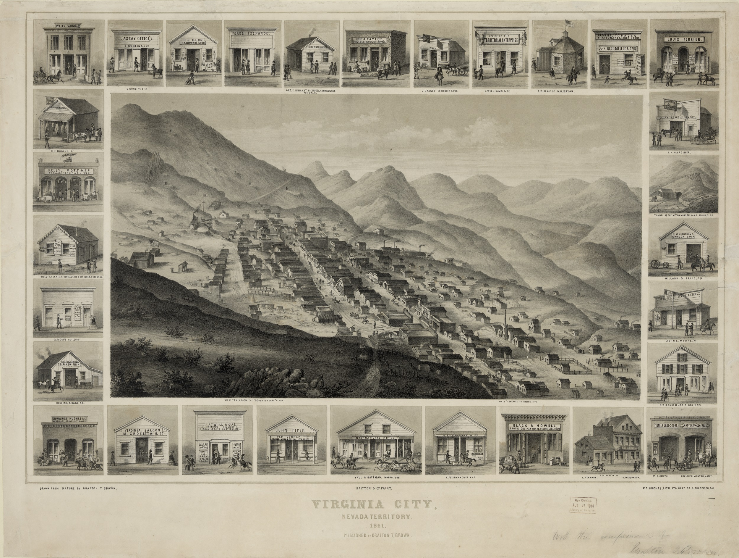
To bring colonized lands into conformity with Euro-American notions of private property, the urban grid has long operated as a primary mode of spatial organization in towns and cities within the Americas. As Thomas Cummins remarks in his analysis of Spanish colonial urban planning, the grid is both universal, so it can be conceptualized and disbursed throughout an empire, and malleable, so it can be adapted to a particular locality.25 This fluid transition between the geometrically abstract grid and the local landscape is expressed in Bruno Latour’s theory of the “immutable mobile,” an inscription that does not lose its internal proportions or logic when flattened, moved, reproduced, superimposed, or recombined within a larger system.26 Latour’s ideal immutable mobile is linear perspective, a system of optical consistency founded on the grid that lends itself to rescaling and transposition across time and space. Brown’s bird’s-eye view of Virginia City captures the dependency between the cartographic grid and landscape images through linear perspective.
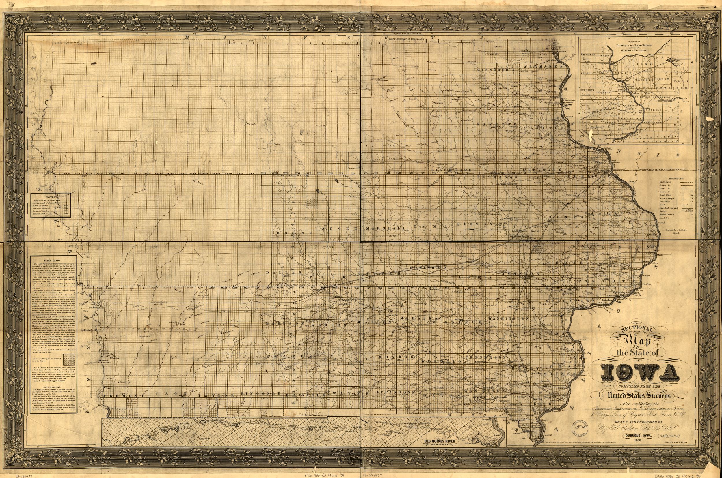
As an immutable mobile, the grid operated as a latitudinal language of present and future territorial expansion throughout the Americas, including in the United States as part of the visual language of Manifest Destiny. Weems asserts that the grid plan was the spatial strategy settlers employed to comprehend an otherwise illegible Midwestern terrain during the antebellum period. As often referenced, Guy H. Carleton’s map of Iowa visualizes the rhetoric of Manifest Destiny as settlements and topographic details are clustered along the eastern border, articulated by the curves of the Mississippi River (fig. 6). In comparison, the left side of the map is almost entirely empty, predominantly articulated as grid, bringing land yet to be colonized into a stable and familiar framework primed for Euro-American settlement. As Weems writes, “In terms of vision, the right angle became a standard component of the new American landscape.”27 He also contends that the right angle developed into the visual principle for settlement, denoting unclaimed terrain that “amplified the mythology of the frontier as a place of open-ended possibility.”28 As an “inexhaustible” mineral deposit, the Comstock proposed a similar open-ended geometric quandary.
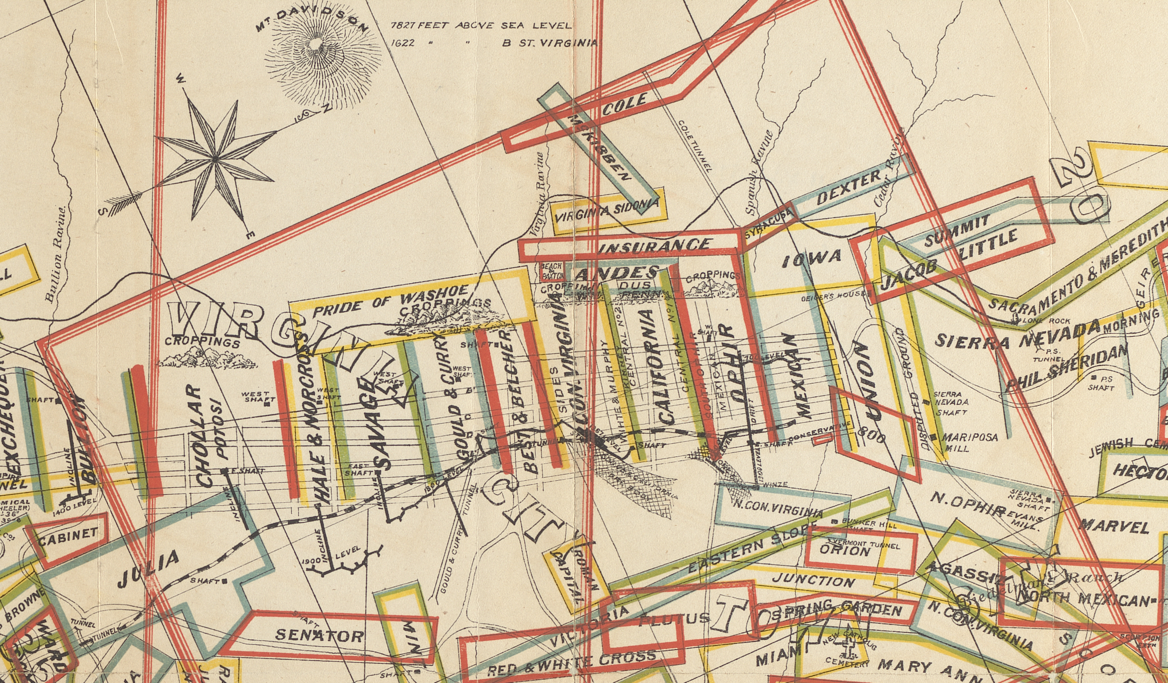
The right angle of expansion gains additional meaning in the context of Virginia City and the broader landscape of the mineral-rich Intermountain West when turned down, toward the subterranean. In The Production of Space, philosopher Henri Lefebvre differentiates the gridiron plan of the urban city from rural places organized for extraction. Urban plans in places like the Intermountain West operate as “though riches produced were riddled through the gaps in the grid.”29 Brown’s map of Virginia City portrays the spontaneous generation of Western civilization’s iconic grid plan in the middle of the Virginia Mountains as a result of the precious metal encased in ore beneath the streets. Yet the map hides how closely entwined these grids were with one another. In 1873, a surveyor and mapmaker named T. D. Parkinson documented the location of each claim on the Comstock Lode while also including an overlay of the town’s streets (fig. 7). The city sat directly over mining claims held by the major companies in town, and C Street linked together the Chollar-Potosi, Savage, Gould & Curry, and Ophir mines on the surface. Running parallel to the major avenues shown in Brown’s cityscape, the silver veins of the Comstock Lode and its surrounding mines would be propped open with Deidesheimer’s three-dimensional grid.
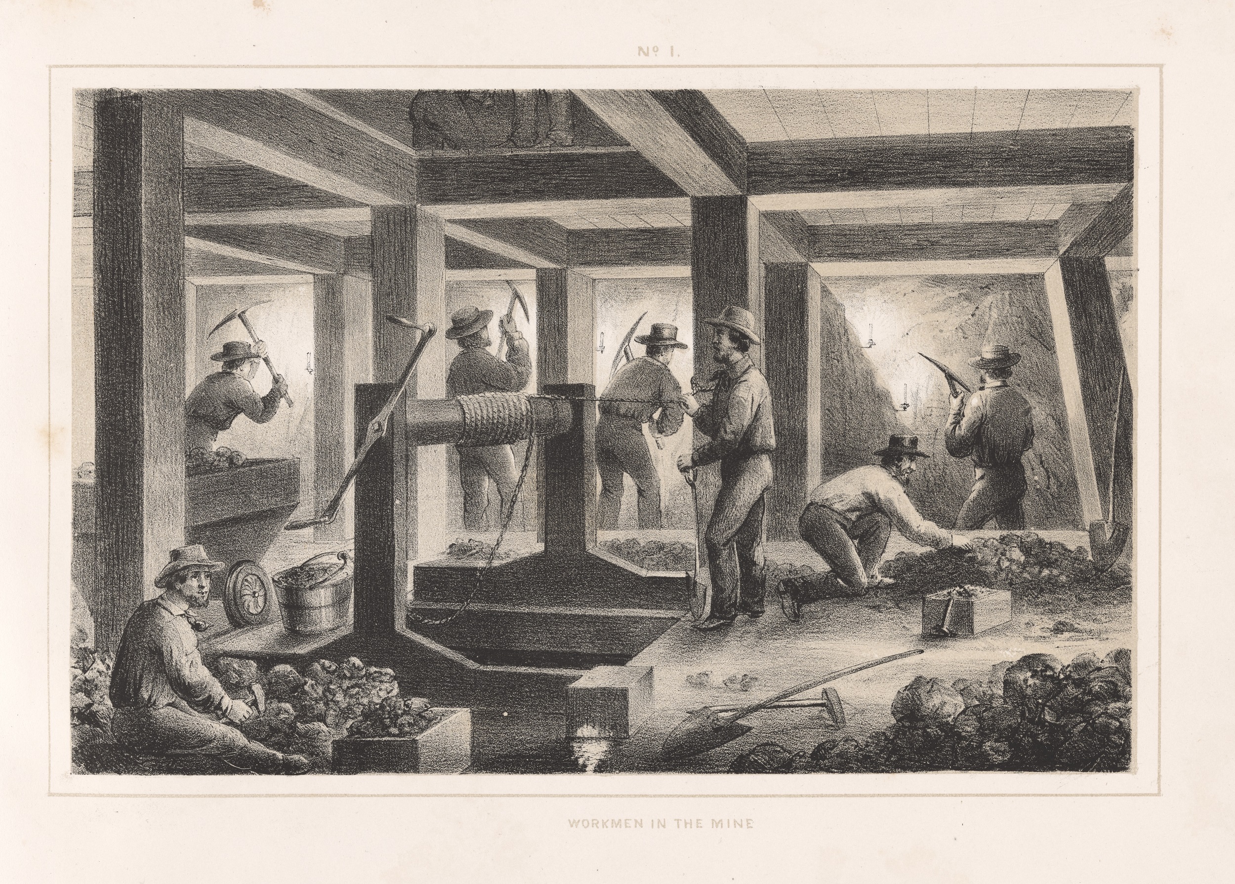
The grid became a visual device for the owners of the Gould & Curry mine in 1863, when they assembled a promotional volume of lithographic prints that visualized the entire workings of the silver mine and millworks for potential investors. Two visual interpretations of these timbered galleries were included in the volume. The first was Workmen in the Mine, which places the potential investor underground, where the vast majority of the company’s workforce labored (fig. 8).30 Squared timbers break the visual plane into foreground and background, showing how workers continually negotiated the spaces between timbers to extract, break, and sort rich ore. These large galleries visually recall familiar architectural structures above ground, whether in Virginia City for the miner or New York for the investor. As a complementary image, the final print expands this scene into a two-dimensional cross section of a vein and mine, pivoting the horizontal grid of Manifest Destiny on its axis (fig. 9). The articulation of space from the defined rock ridge on the right to the ordered though empty grid on the left reflects the same logic found in Carleton’s map. Yet these timbers reorient the grid from a process of colonization across the land, which historically has been signified through land clearing and deforestation, to a colonization duplicated stratigraphically underground. As environmental historian James W. Moore has aptly argued, to accelerate a horizontal frontier across the Earth, one first needs a vertical frontier that moves into earth to extract coal and capital.31 Furthermore, this pivoting recalls Lucy Lippard’s notion of the “inverted city”: the vacant spaces of mines and gravel pits left behind in service of raising the contemporary metropolis.32 It is no surprise that Deidesheimer’s system, as a critical and familiar structure of spatial translation and transposition, became the visual hallmark of the Comstock Lode. The expansion of a mine could be measured, evaluated, and forecast by the investor-viewer through subterranean grid systems, allowing the public to comprehend this otherwise inscrutable space.
O’Sullivan’s initial stereoscopic negatives of the mine play with this rhetoric of the ever-expanding grid. The stereoscopic image is dependent on the paired captures of a scene at slightly different angles to mimic the placement of human eyes. The subtle difference between the two views produces the optical illusion of perspective, operating as an immutable image that can exist without connection to a material locality.33 O’Sullivan’s Worker, Gould & Curry Mill (see fig. 2) isolates and compresses the worker within a single unit of timbered space, which would have been doubled in the original negative. In effect, the photographic frame supplants the square timber unit, dislodging the scene from the timbered structure of the mine to assume its visual work. From the safe distance of an armchair, the anonymous viewer is left to speculate not only on the contents of the rock walls within the image but also on how many other deposits might be found within the expandable grid of the mine.34 And yet, the stereographic reframing of these spaces prevents the pictorial unit from being reconciled with the original structure and hides its material limitations. In essence, Crushed Timbers (see fig. 1) operates as a blockage to this speculative extrapolation by encouraging the replication of disaster and risk over reward.
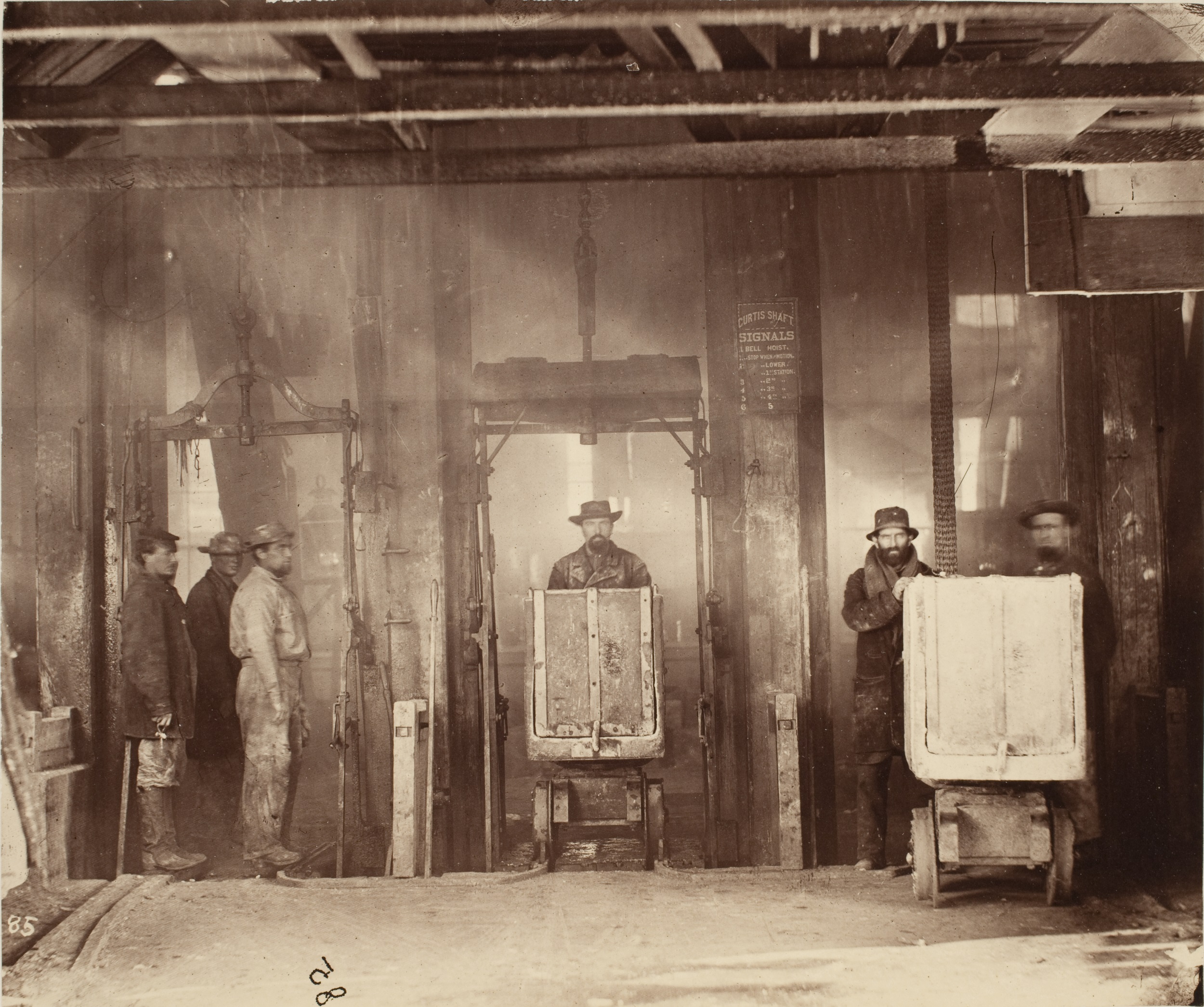
Instead of reproducing these subterranean images, King only included O’Sullivan’s photograph of the surface entrance to this vast gridded structure in the volume Mining Industry. As the frontispiece for the publication, the image shows the entrance to the Savage mine that was adjacent to the Gould & Curry mining works, representing a critical juncture between the surface and the mine (fig. 10). Operating as a triptych, the image is divided by three mechanical lifts buttressed by large wooden posts. At far left, laborers wait to be lowered into the heart of the mine, while at right, two figures push a cart forward, as if delivering extracted ore to the viewer by way of the silver-based photograph. Supporting a centrifugal interpretation, this liminal image of the Savage entrance suggests a bridge between the abstracted diagrams of Deidesheimer’s grid structure reproduced in the report and the surface that would supply and support not only the laborers working the mine but also the timber and lumber industry that would grow to support this extraction.
Ordering Ecologies around the Timbered Mine
The abstract grid provided an ideal solution to the problem of silver’s inexhaustibility in the Comstock Lode, and straight timbers from mature trees allowed it to be realized. In 1893, William Alvord, former president of the American Forestry Association, would comment on this connection: “To rifle the mineral kingdom of its glittering treasures, man had first to levy upon the resources of the vegetable kingdom. Without the aid of forests, the wealth of the Comstock would have been as far beyond human reach as the fabulous secrets of the alchemists.”35 Echoing Alvord’s comment, Crushed Timbers visually refocuses discussions about the mine away from hard-rock walls to the timbered frame, compositionally displacing the miner and his pickax to the periphery. In this way, O’Sullivan’s photograph disrupts the logic of the ever-expanding grid by stressing the material limitations of these timbered beams. The networks developed to cut, process, and move timber that helped realize these structures also came with significant ecological implications.
The pine-bearing mountain ranges around the Comstock Lode were and remain Numu homelands, particularly for communities now known as the Pyramid Lake Paiute Tribe. As remarked by local journalist Dan De Quille (William Wright) of the Territorial Enterprise in 1876, the Numu People are the original “owners of all that region in which the Comstock mines are situated.”36 Forested areas west of Virginia City are populated with nut-bearing pines and berry-producing juniper trees, both of which are central to Numu creation stories.37 Miners sought the use of these sacred pine and juniper trees to hold up shafts running into Mount Davidson, reaching more of the silver veins below the surface. The seeds of these trees, known in the Numu language as tuba, are the central cultural symbol of regeneration and nourishment in the diverse and fragile desert ecosystem of the Great Basin and, thus, critical to Indigenous foodways throughout the region. Using different types of baskets, women prepared tuba by cracking the shells, sifting debris, and subsequently washing and drying them. These same maneuvers were also evoked to separate silver ore from gangue rock by Numu men hired as the first miners to work with Henry Comstock in 1859.38 When more established industrialists entered the region and organized mining claims, Numu workers were eventually barred from the industry to protect jobs for white miners, yet the trees on the surrounding land remained central.39
As evident in O’Sullivan’s photographs from around Virginia City, the surface environment of the Comstock Lode was not heavily forested and thus could not materially realize Deidesheimer’s timbered grid. Before the square-set timber method was invented, miners attempted to draw on the immediate resources around Mount Davidson. In a short history on timbering methods from 1881, De Quille notes that the dwarfed nature of juniper and pine trees in the immediate area required miners to “splice two sticks by fastening them together with iron bolts and bands” to create a single beam for structures underground. He also mentions that such jury-rigged braces often caused “danger and trouble from their being crushed in.”40 As the resources of the immediate landscape could not support Deidesheimer’s grid, industrialists looked west toward the pine nut forests near Lake Tahoe that remain central to Maidu, Washoe, and Pyramid Lake Paiute Peoples of the region today.
Albeit frayed, cracked, and splintered, wood from old-growth oak and pine groves located around Lake Tahoe is the primary subject of Crushed Timbers. Da ow aga, meaning “edge of the lake,” is the original name given to Lake Tahoe by the Washoe (Wá∙šiw) people. According to Washoe historian Jo Ann Nevers, from time immemorial, the whole community gathered every spring at the lake to recognize its centrality to all life in the region, including the forests, plants, fish, animals, and humans, while also reaffirming tribal unity. The lake lies at the heart of Waší∙šiw ɁitdéɁ, the homelands of the Washoe community, connecting waterways such as Watahshemu (Carson River) and Welganuk (the Truckee wetlands) to other bodies of water, including A’ waku da ow (Pyramid Lake, which is known as Kooyooe Dukadu in Numu), which King surveyed and O’Sullivan photographed.41 For the Washoe community, Da ow aga is a bridge between the incredible diversity of land and environment of the Pine Nut and Virginia Mountain ranges to the east and the Sierra Nevada Mountains to the west.
The Pine Nut Mountains are named for the groves of yellow-pine trees whose nuts are an essential food source indigenous to the region. A crucial source of protein, pine nuts and acorns were harvested, prepared, and stored to help communities survive the harsh mountain winters. During the fall season, Washoe ceremonies, stories, and games were organized around tah gum—the harvest season for pine nuts.42 Nut harvesting also propelled the development of intricate basketwork still stewarded by Washoe artists today. Locals cared for these old-growth groves, from the collection of acorns, nuts, and pine needles to controlled burns used to regenerate key plants for basket construction every season. The shifting ecosystem caused by deforestation for mining and Euro-American fire management disrupted these groves and continues to threaten trees and grass critical to these collecting practices.43
The importance of these seeds and nuts to the Numu and Washoe Peoples was so well known in the late nineteenth century that a journalist going by John Samson mentioned them in an article about the King survey for Harper’s New Monthly Magazine. Reproducing many photographs from the survey, the article follows the narrative of the exposition photographer, suggesting that the essay may have been written by O’Sullivan using a pen name. Robin Kelsey has analyzed parts of this article in relation to the allegories of the camera’s silvered origins in the mine, but the article also mentions other aspects of the ecologies around Virginia City.44 Discussing the principal article of food for the region, Samson recounts, “This nut, when dried, is sometimes pounded into a coarse meal, which is made into cakes and baked in the ashes. . . . In taste the nut is resinous, and to the palate unaccustomed to the food not extremely agreeable.”45 Roasted pine nuts, as a local staple, were transformed into a curiosity for travelers. The survey’s botanist, William Whitman Bailey, wrote to his brother in November 1867, “As I write this letter, I am engaged in chewing the pine nut or large edible fruit of Pinus Fremonteau, sold in large quantities by the Piutes [sic]. I met a hundred or more Indians a few days ago . . . with horses loaded with nuts.”46 As the survey team entered Virginia City during the end of nut harvesting, the politics of pine trees and their relationship to local foodways could have been on O’Sullivan’s mind. Pine trees, however, cannot bear nuts if they are cut down.
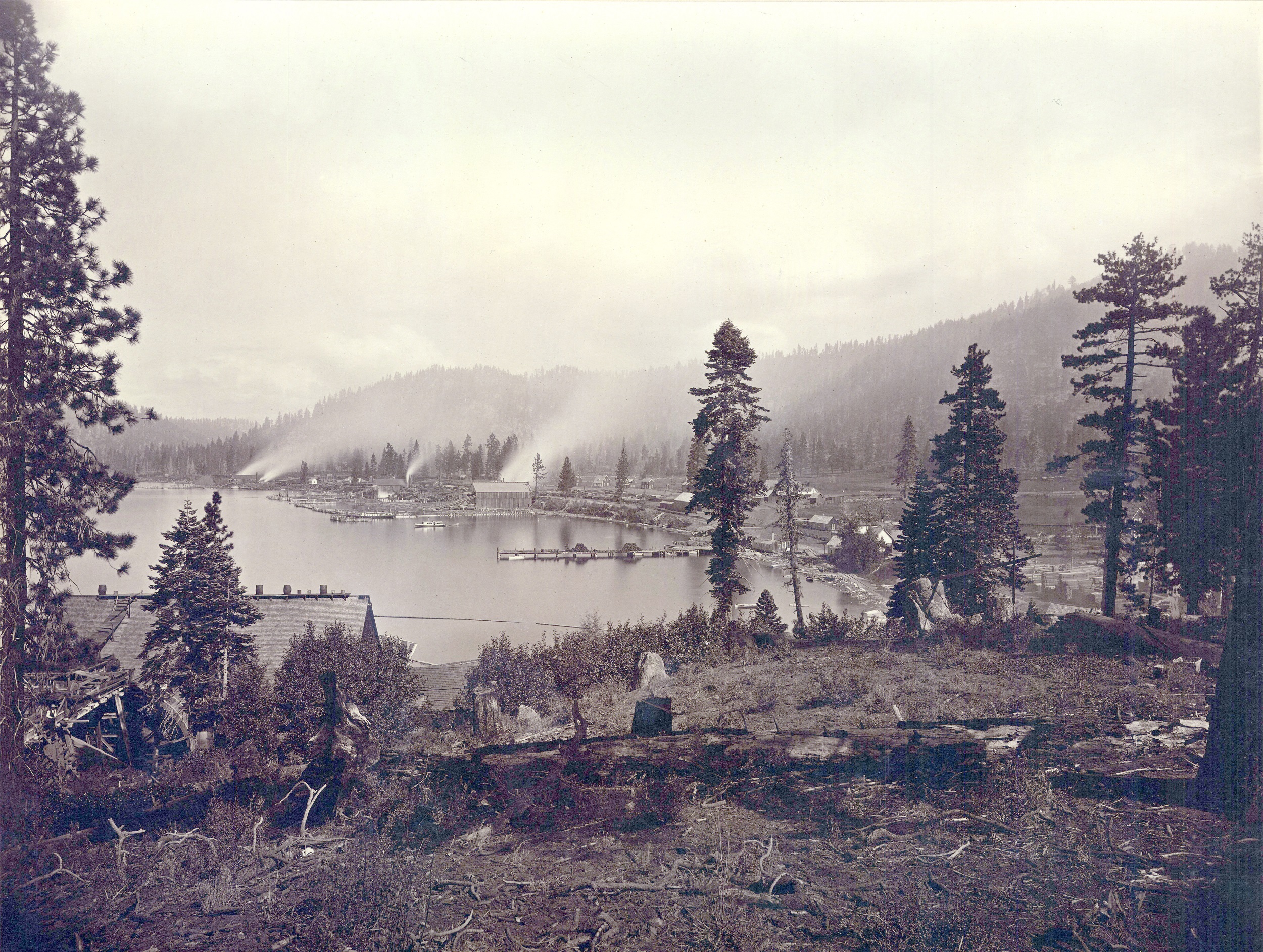
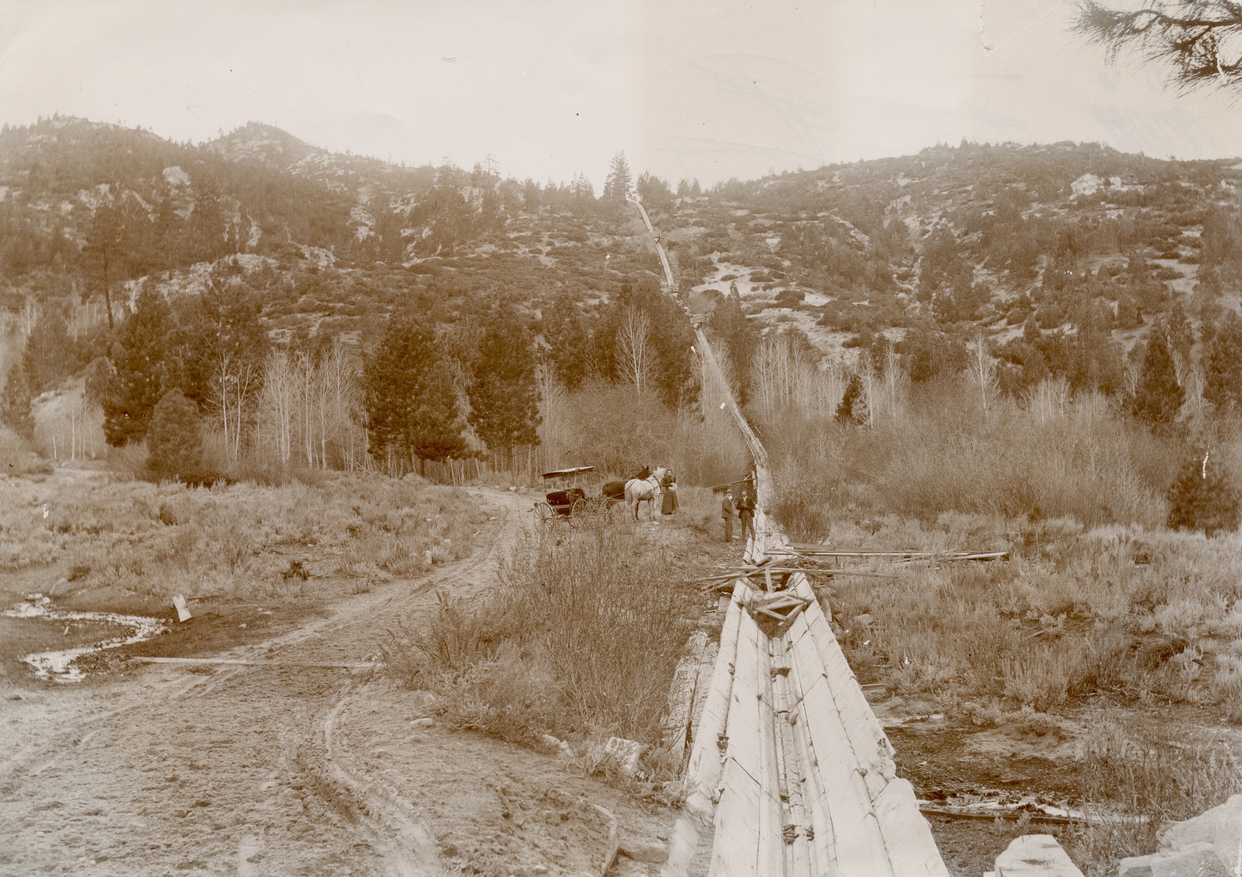
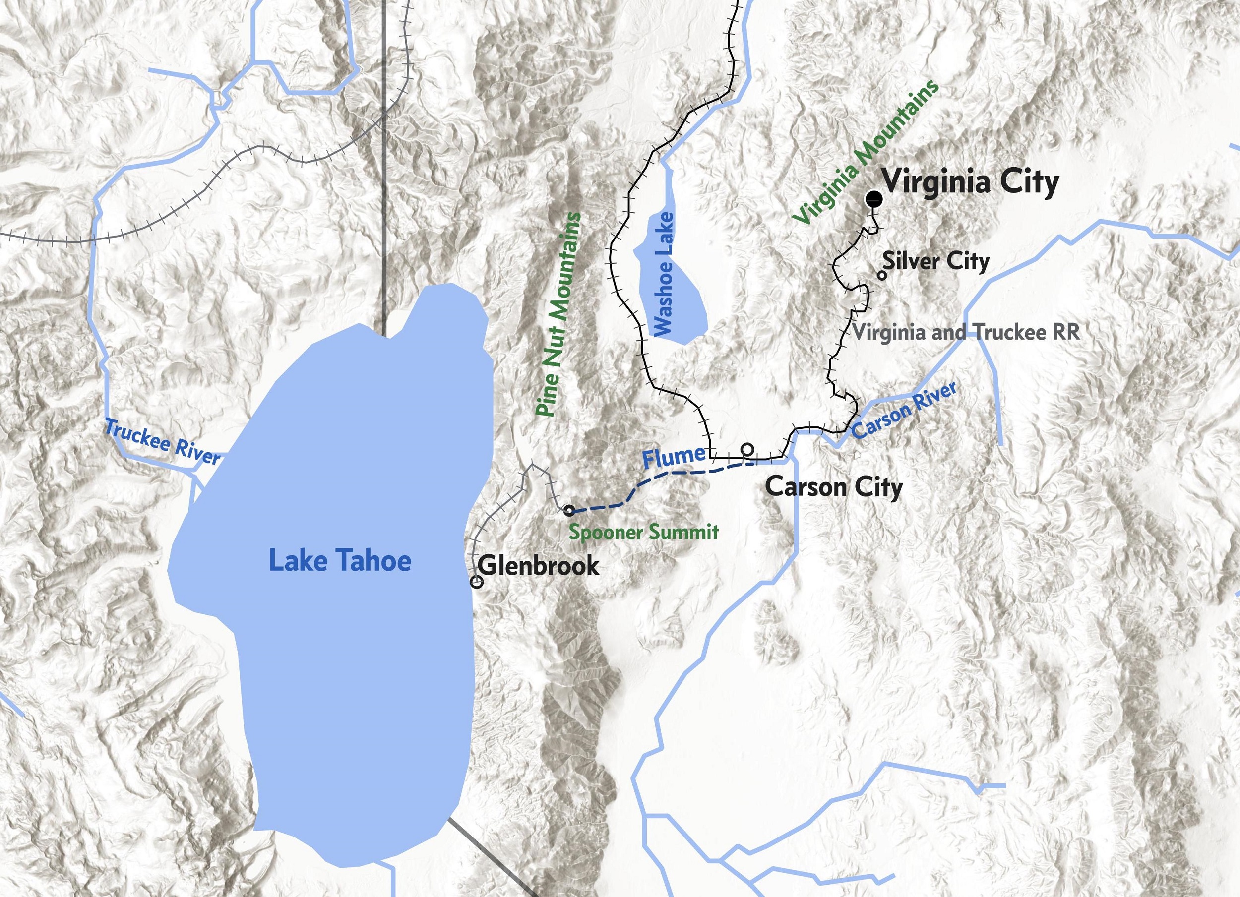
The lumber industry reshaped the environment around Lake Tahoe to support the Comstock mines, targeting overlapping areas of tall old-growth trees once harvested for their nuts that were ideal for Deidesheimer’s grid. As summarized by environmental historian Andrew C. Isenberg, “Wood was both the primary fuel and the leading construction material for nineteenth-century Americans.”47 In California and Nevada, industrialists described the Sierra Mountains as equally inexhaustible as the mines they would support, and the shores of Lake Tahoe became a central processing center starting in the early 1860s. At the center of this industry was Duane Leroy Bliss (1833−1907), who established the Carson and Tahoe Lumber and Fluming Company in 1873 to expand systems of flumes and railroad networks to supply Comstock mines.48 In 1876, Bliss hired the industrial photographer Carleton Watkins to photograph Lake Tahoe and parts of the company’s infrastructure, including Glenbrook Bay on the lake’s eastern coast (fig. 11). A fallen pine among scattered stumps defines the foreground in Watkins’s image of Bliss’s processing mills along the shore. Smoke from mills obscures the distant mountains while emphasizing the lone trees scattered around the edge of the lake. Mature trees were cut down in the region and moved by water to the centralized processing plant at Glenbrook Bay. From there, timbers were taken up the mountain ridge by train to Spooner Summit and then sent by a water-powered flume to the lumber yard at Carson City (figs. 12–14). When King’s survey team was in the area in 1867, engineers with one of Bliss’s future companies were improving fluming networks through the introduction of a v-flume, speeding up the movement of timbers across greater distances.49 Water was an essential source not only for the growth of these timbers but also for their movement across this mountainous region.
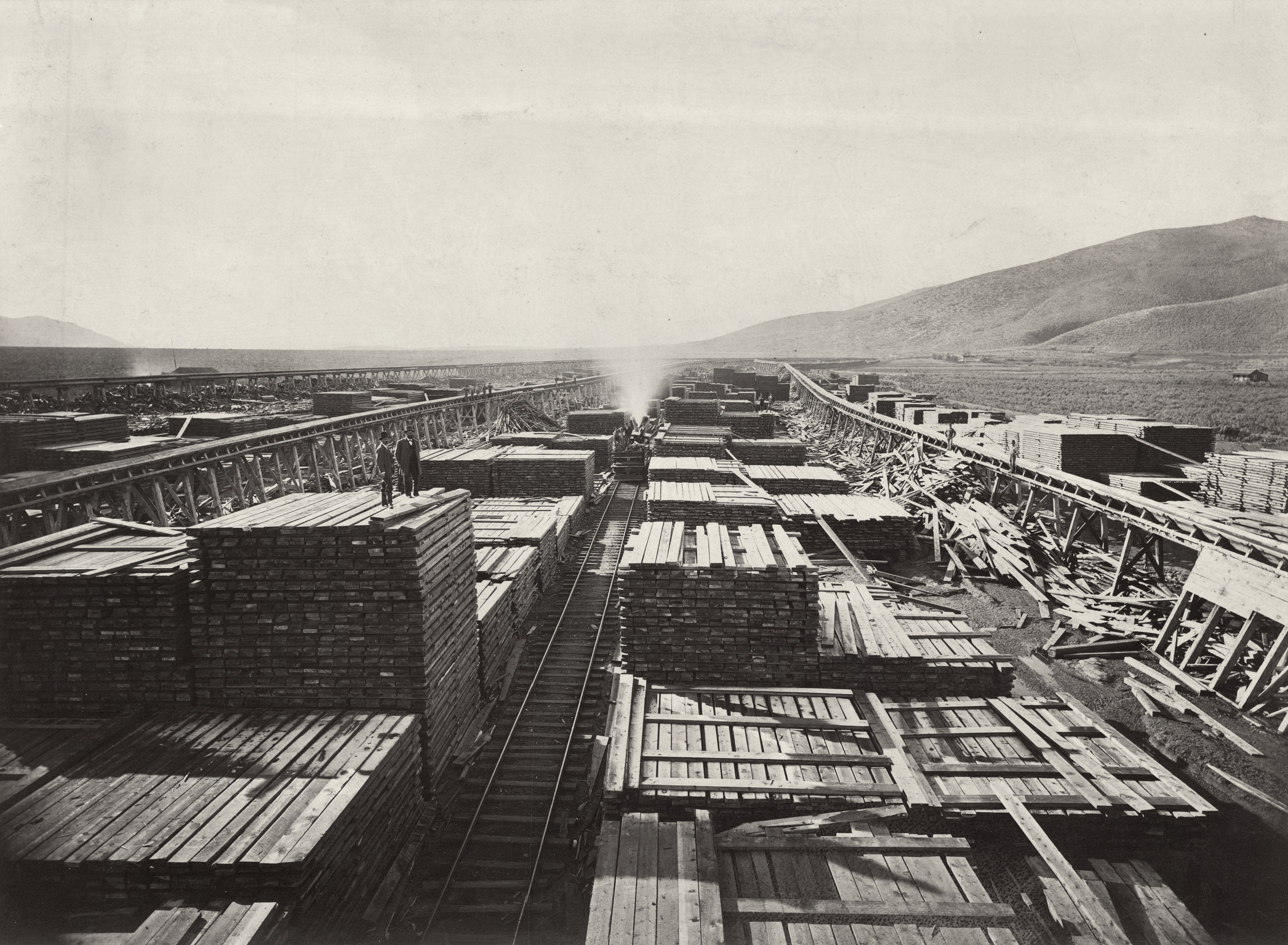
Watkins captured the sheer amount of timber in transit for Comstock mines in Upper End of Carson and Tahoe Lumber and Flume Co. Lumber Wood Yard near Carson City, or simply Upper Lumber Yard (fig. 13). The composition features geometrical units of processed wood organized along the central railroad tracks, as well as two straight, water-powered flumes raised on both sides. Akin to the Gould & Curry lithographs, the composition of Upper Lumber Yard suggests an endless supply of timber, naturalizing notions of industrial might and progress also connected with the grid, as Christine Hult-Lewis observes, but particularly with the Comstock region’s inexhaustible veins.50 Through this commission, Watkins visualized how Euro-American industry denuded and reordered one landscape to extract and process another.51 Not only were timbers cut into square columns to be incorporated into square-set timber structures, but other noneligible trees and lumber waste were also sold by the cord to feed generators to hoist ore to the surface and pumping stations to prevent mines from flooding. As a structural and energy resource, wood also kept the space of the mine open for the speculator’s gaze via the camera. By including two men in business suits on the left, Watkins’s composition visually equates the landscape’s surface with the commodity of processed wood, removing all traces of how Indigenous Peoples and the mining and timbering industries were connected through the land.
Internal and External Collapse
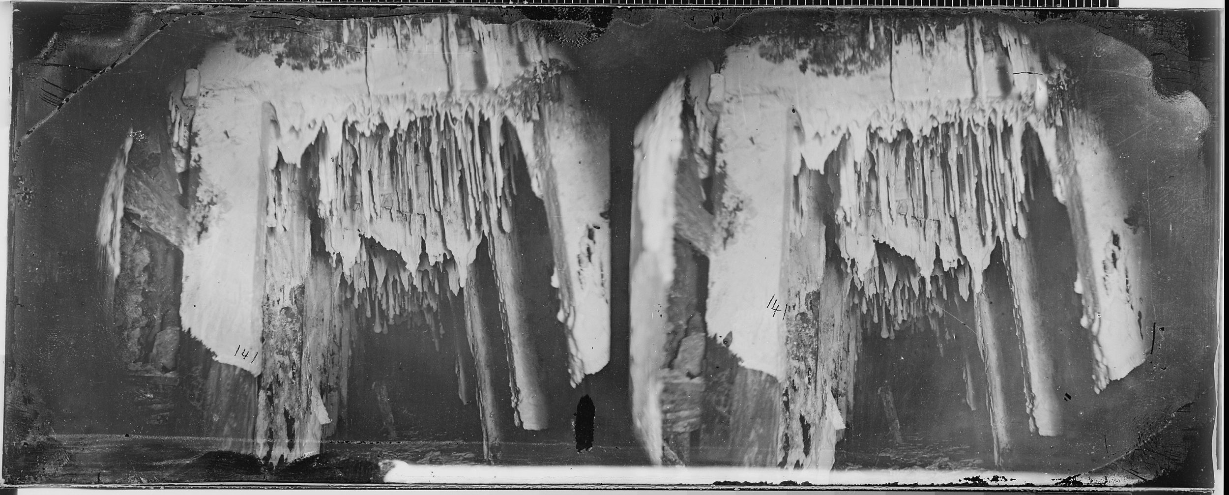
O’Sullivan’s Crushed Timbers (see fig. 1) challenges the stability of the networked systems around timber, whether the grid structure itself or the material assurances beyond the frame. Instead, the image amplifies the precarity of timber within these unnatural subterranean spaces. The Comstock mines were uncharacteristically warm and damp for the industry, often causing fungus to grow directly on these beams. In one of his stereographic negatives, O’Sullivan captured how fungus grew in vertical structures across posts to reclaim spatial voids opened by timber (fig. 15). The combination of fungus and the immense pressure of the earth warped wooden beams to cause cave-ins. King’s survey team happened to be stationed in Virginia City during the time of year when mining companies would invest in retimbering sections of their mines. Most of the mining accidents reported in the Territorial Enterprise during O’Sullivan’s time in Virginia City were related to these same timbers. Accidents were categorized as the crushing of bones and limbs by falling beams and rock or the driving of a pick into a leg.52 The almost satirical placement of the miner’s leg and the pickax at the periphery of Crushed Timbers seems to signal this causality. In other words, the image reads clearly as a dimension of bodily harm specific to the timbering process, as opposed to other types of cave-ins caused by rock extraction. Despite the severity of such wounds, most miners survived these incidents. Yet, in January 1868, the mining process came to a halt after a severe snowstorm disrupted the supply chains between Lake Tahoe and Virginia City, pausing not only the delivery of timber but also that of wood to run lifts, mills, and smelters necessary for the processing of ore.53 O’Sullivan created Crushed Timbers in a historic moment of disruption linked to timbering.
While O’Sullivan’s Crushed Timbers captures the lived reality of these human-made vacuums within the earth, subterranean open spaces also threatened the stability of the urban grid. Severe timber collapses in the mines caused pipes to burst, water wells to disappear, hoisting works to fail, smelting chimneys to lean, and streets to crack. During the fall of 1867, the Savage and Chollar-Potosi mines suffered two extensive cave-ins just north of the Gould & Curry claim. On the night of September 9, a cave-in or “extensive settling of the timbers” occurred on the seventh level of the Savage mine, creating a “considerable” disturbance along the main thoroughfare of C Street. Describing the damage, a reporter noted two days later that “downward motion still continues”: major buildings along the street were “terribly cracked and swayed”; “boards are bowed out and almost ready to break”; and “plastering is falling off the walls and the brick columns between the doors . . . are badly cracked.”54 Another cave-in happened at the Chollar-Potosi on the afternoon of October 24, “which extended to the surface and left a great chasm extending the whole width of B street.”55 Similar to a collapse that had reached the surface during the previous spring, this one created a sinkhole of approximately fifty feet in diameter, engulfing the home of a resident named Patrick Price, whose body was never recovered. These timber cave-ins prevented King’s team from accessing key tunnels on the Comstock, requiring Hague to rely on old, discontinuous data recorded by various mining company managers to create stratigraphic maps included in the geological report.56
Read against the crystallized geometries of the cartographic grid, O’Sullivan’s Crushed Timbers operates as the other half of a dialectic, evoking themes of material instability, disorganization, and fragility. Warping, cracked, and frayed, the timbers in this image resist the imposition of the grid as enforced by the stereographic image. The intimacy of the tight space of the mine even allowed O’Sullivan to capture growth rings of a beam at center, suggesting its previous life as part of the groves around Lake Tahoe. Deidesheimer’s abstracted honeycomb structure required to hold these underground spaces open is compressed into a single unit inscribed by the camera’s frame. By depicting this square of the mine’s timber structure with collapsed beams, O’Sullivan emphasizes the unstable relationship between surface and subterrain that was part of the lived reality of Virginia City. Framing this instability comes in contrast to King and Hague’s technical praise of the square-set timber system in the official report.
If the whole structure of the mine was constantly in a precarious state, as proposed by Crushed Timbers, what of all the environmental and human networks intertwined with those wooden supports? Newspaper accounts from the period suggest that King’s team witnessed the start of a socioeconomic crisis, one immediately felt by local Indigenous communities who stewarded these landscapes. In March 1867, a reporter for the Territorial Enterprise related that more Indigenous women were coming into the city in search of wood since supplies had become inaccessible in the valley due to the industrial development of the mining industry. Recognizing this shift and the critical importance of nut-bearing trees to the community, the anonymous journalist glibly asked, “Wonder if they ever think of the time when all the hills were clothed with nut-pines?”57 While this question glosses over the slow violence of industrial development, an unpublished manuscript by De Quille directly addresses these environmental shifts. In “Notes on Paiute,” the local journalist wrote, “The ax of the white man swept away all these pine orchards to the sorrow of all the [Indians] . . . speeches [were] made by leading chiefs when the Whites began cutting down the pine orchards.” De Quille also noted the impact of ranching on grass groves needed for arrow making and basketry, which in 1861 had “presented the appearance of field of wheat” and was now, by 1876, trampled by cattle.58 Even though De Quille’s rhetoric enforces settler-colonial tropes around the disappearance of Indigenous lifeways, these statements also admit to Indigenous protest around the decimation of the pine-nut forests.
Numu and Washoe leaders actively spoke out against the environmental damage being wrought by the mining industry as their communities experienced the collapse of food systems structured around these pine trees. The Washoe leader Gumalanga (Captain Jim) visited both local and state officials several times following the Pyramid Lake War of 1860, complaining about Euro-American miners who lumbered on Washoe lands. Washoe leaders decided to advocate for a treaty with the US government that would clearly define community land and resources, which were quickly being depleted.59 Only in 1892 were leaders able to raise enough money to fund a delegation trip to Washington, DC, to entreat President Benjamin Harrison to protect these groves and Da ow aga (Lake Tahoe). By this point, mills around Lake Tahoe were forced to close, as loggers had consumed all the wood within two miles of the lake’s shore and along the Truckee River.60 Despite other attempts at reserving land within the laws of the United States, the federal government did not officially recognize the Washoe Tribe until 1936 and, only then, established a reservation far from traditional family camps.
For those closer to Virginia City, the Pyramid Lake Paiute Reservation would not shield the community from environmental impacts caused by the timber and mining industries. As recounted in her famous autobiography, Life Among the Piutes, Numu activist Sarah Winnemucca (c. 1844−1891) recounted not only the violence of miners toward Indigenous Peoples of the region since the Pyramid Lake War of 1860 but also the contradictions of having to live under the US reservation system. The government established programs to enforce farming and ranching on the Pyramid Lake Reservation, which produced wheat yields to be sold to white populations below market price without proper compensation from subagents. White ranchers also spread rumors of Native-led rebellions to keep the US Army posted in the region, forcing Indigenous Peoples not only to live under the constant threat of sanctioned violence but also to suppress any complaints over the illegal use of reservation land.
To escape the restrictions and abuse of the reservation system, around 57 percent of the community relocated to Virginia City, according to anthropologist Gene Hattori.61 Indigenous families eventually built encampments on the east side of the city, outside of the contained urban grid, often placing them at the doors of mining companies.62 Native workers were frequently barred from mining underground as racist attempts to protect white employment, and I have found no evidence of a mining company that explicitly hired Indigenous workers. While motivations to work in settler-colonial industries were highly varied and complex, Winnemucca notes that many members of the community were building ditches for irrigation, timbering forests for mines, and working for the railroad companies for little pay simply to keep the peace and prevent the genocidal violence that was commonly directed toward Indigenous Peoples in mining areas.63 Additionally, Indigenous women were often employed as laundresses, maids, and kitchen helpers in local boarding houses, all supporting the infrastructure for mining and timbering.64 Relocation increasingly shifted the Native community’s life to Virginia City’s gridded streets, whether in the daily practice of selling fish and pine nuts in markets or as a setting for ceremonial ghost dances in the city’s streets, as reported by local newspapers.65
Many non-white laborers faced extreme racism from Euro-American settlers, as evidenced by the number of writers who referred to Indigenous workers by the harmful stereotype of the “savage digger” in the press. White miners developed this derogatory epithet for Indigenous individuals in the gold fields of California, ignoring the extensive knowledge systems many communities developed for locating roots and vegetables in the desert. Anthropologist Allan Lonnberg interprets this slur as a manifestation of the white male ego facing persistent failure at prospecting for precious metals.66 Deflecting from frequent disappointment in this unknown terrain, Euro-American settlers often pitted Numu and Washoe laborers against Chinese workers when firewood or pine nut supplies ran low.67 Such rhetorical moves temporarily absolved the predominantly white, Euro-American mining industry of environmental responsibility.
As mentioned above, the members of King’s survey interacted with Indigenous workers in the streets of Virginia City, including local fishermen. Toward the end of 1867, King would personally form a friendly connection with an unnamed Numu fisherman, who eventually asked the geologist to act as a mediator between local leaders and the Nevada Superintendent of Indian Affairs, H. G. Parker.68 Probably taken around this same time is a portrait of two white men and thirteen Indigenous men and women along the Truckee River that runs between Lake Tahoe and Pyramid Lake (fig. 16). The fourth figure from the left is Agent Parker, and I believe the fourth figure from the right is King. At the center is likely King’s hired scout, Natchez Winnemucca (around 1844−1907), the son of the famous Numu leader Winnemucca (Poito) and brother of Sarah Winnemucca, who lived in Virginia City during this period.69 While it must remain a hypothesis, this portrait may have been a record of such a requested mediation.
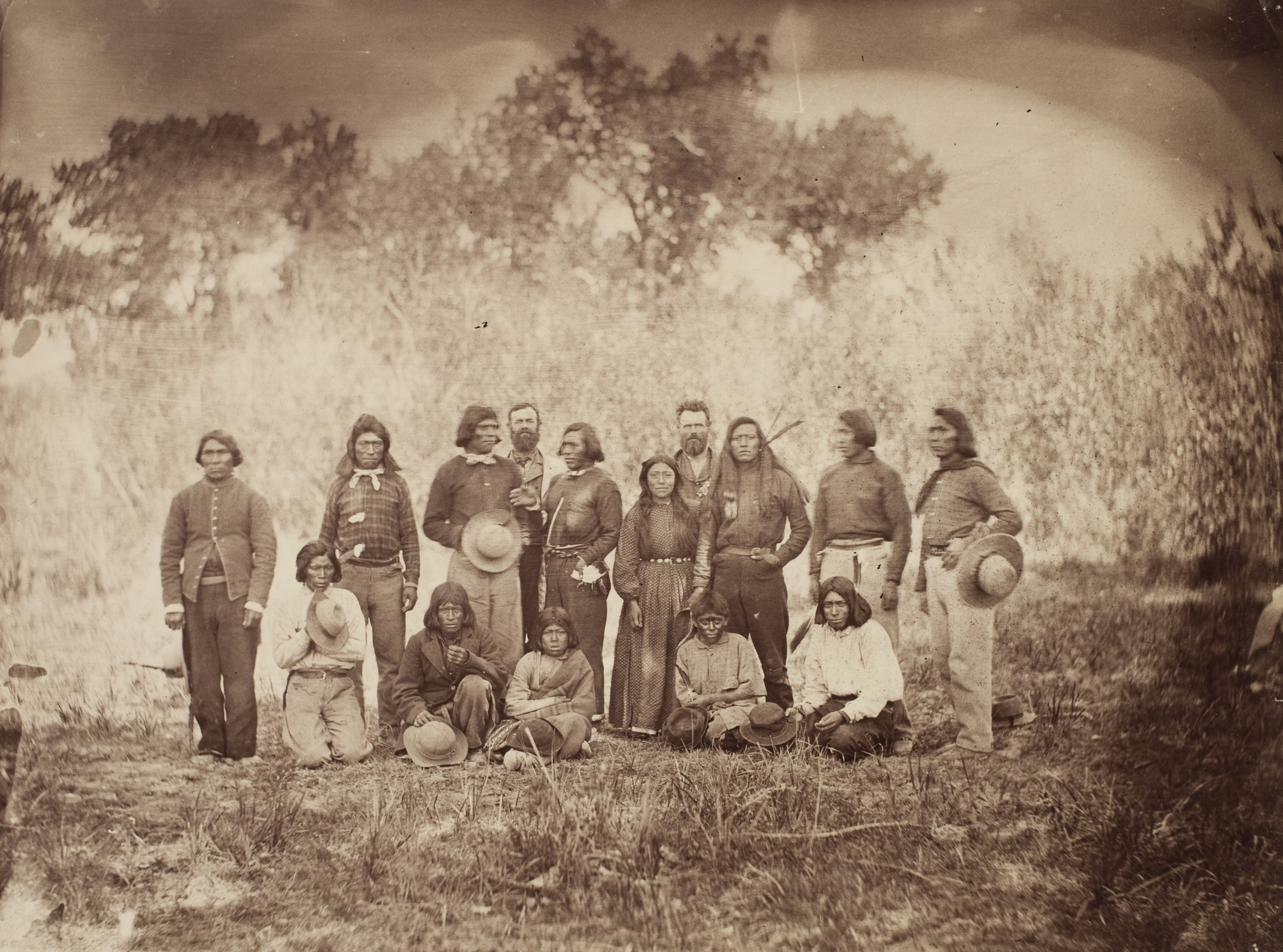
Natchez Winnemucca acted as a local diplomat and was probably hired as a guide for King’s survey team during the winter of 1867/68. Hiring Indigenous guides was a fairly common practice for survey teams, yet many scouts remain completely unnamed in the records, often appearing only within unpublished survey photographs. King, however, mentions the hiring of the “Chief’s Son” in his travel diary in December, while the team was stationed in Virginia City, which would have referenced Natchez Winnemucca. The young leader guided King through the Humboldt Sink, which was located about seventy-five miles east of Pyramid Lake.70 According to his sister’s autobiography, Natchez Winnemucca had been living in Virginia City since the previous year because of the mismanagement of the reservation.71 His intimate knowledge of the terrain likely allowed King to locate rock formations connected with new lodes. Eventually, King would return to the area in 1873 to consult unnamed Numu and Shoshone leaders about the names of regional mountain ranges for his official government maps.72 Unfortunately, politicians in Washington, DC, struggled to understand and pronounce Indigenous words for regions of the Great Basin, and these official names were changed, whitewashing critical Indigenous collaborations.73 While Natchez’s impetus for taking up this role is unknown, his motivations may have been partially diplomatic since King was operating as an unofficial mediator between Parker and Numu leaders on the issue of deforestation, all while the survey team worked to advance a mining industry dependent on these pine forests.
As the expedition photographer in Virginia City who worked with Numu guides, O’Sullivan was in a unique position to understand the ecological connections between the silver mine, forested timbers, and Indigenous foodways. Yet the photographer left no archive verifying these connections. Instead, Crushed Timbers operates as a new lens not only for understanding these precarious relationships above and below ground but also for seeing anew the intricate relationships between Euro-American settlers and Indigenous communities in this region mediated by timbers.
Conclusion
Silver’s environmental costs often fall outside the photographic frame, yet O’Sullivan’s Crushed Timbers reveals a dialectic of power in the history of material extraction. Instead of articulating an expanded grid network, his subterranean photographs insulate and entomb miners who are framed internally by wooden beams and externally by the photographic crop. This photograph calls into question the entire ecosystem required to maintain the fragile space of the mining tunnel, pointing to silver’s negative ecologies. By considering how O’Sullivan’s photographs reflect period anxieties over mining-tunnel structure, the material politics of the mine and the surface landscape of Nevada merge to reveal the human and ecological stakes of unearthing the world’s largest silver deposit—the Comstock Lode. These images connect back to the surface not only through the ore but also through the timbers that symbolize the greater ecological impact of deforestation and, subsequently, the Numu and Washoe communities’ increased dependence on wage labor. O’Sullivan’s miners ate the pine nuts sold by Numu women on the streets of Virginia City and were protected by the timbers that had been stewarded by Washoe men and women for centuries. While O’Sullivan’s personal position on these issues remains unknown, reading these encounters back into his subterranean images provides a more nuanced perspective on the power of landscape and the silver industry’s landscapes of power.
October 24, 2023: A reference to President William Henry Harrison was corrected to President Benjamin Harrison.
Cite this article: Christine Garnier, “Framing Silver’s Void in Timothy O’Sullivan’s Photographs of the Gould & Curry Mine,” Panorama: Journal of the Association of Historians of American Art 9, no. 1 (Spring 2023), https://doi.org/10.24926/24716839.17162.
Notes
An early version of this paper was presented at “Un-Fair Trades: Artistic Intersections with Social and Environmental Injustices in the Atlantic World,” hosted by the CUNY Graduate Center in October 2019. I would like to thank the staff and archivists who have assisted me with this ongoing project, including those at the National Archives and Records Administration, Washington, DC; the National Museum of American History at the Smithsonian Institution; the Nevada Historical Society; the Bancroft Library at the University of California, Berkeley; the Huntington Library, Art Museum, and Botanical Gardens; and the W. M. Keck Earth Science and Mineral Engineering Museum at the University of Nevada-Reno. This research was supported by funding from the Decorative Arts Trust Summer Research Fellowship Grant, a Smithsonian Institution Predoctoral Fellowship, and a Wyeth Fellowship through the Center for Advanced Study in the Visual Arts at the National Gallery of Art. I am grateful to the two anonymous reviewers for their feedback, as well as Jennifer Roberts, Robin Kelsey, Davida Fernandez-Barkan, Dina Murokh, Lee Ann Custer, Erhan Tamur, and Monica Bravo, who helped shape my treatment of this material. Finally, my gratitude to Naomi Slipp and Jessica Skwire Routhier for their valuable editorial support.
- Mark Twain, Roughing It (Hartford, CT: American Publishing Company, 1872), 378, 380. ↵
- Clarence King, introductory letter, reprinted as front matter in James D. Hague and Clarence King, Mining Industry, vol. 3 of Report of the Geological Exploration of the Fortieth Parallel (Washington, DC: Government Printing Office, 1870). I have chosen to use the term “Numu,” which translates as “The People” in this branch of Numic languages connected to Northern Paiute communities. Within the Comstock Lode area, many of these communities were enrolled under the Pyramid Lake Paiute Tribe. ↵
- See Hague and King, Mining Industry, 25-26. ↵
- Alan Trachtenberg, Reading American Photographs (New York: Noonday, 1989), 144-54. ↵
- Keith F. Davis, “Timothy H. O’Sullivan: Photographer,” in Timothy H. O’Sullivan: The King Survey Photographs, ed. Keith F. Davis and Jane L. Aspinwall (New Haven: Yale University Press; Kansas City, MO: Nelson-Atkins Museum of Art, 2011), 75. ↵
- Robin Kelsey, “Photography and the Ecological Imagination,” in Nature’s Nation: American Art and Environment, ed. Karl Kusserow and Alan C. Braddock (Princeton, NJ: Princeton University Art Museum, 2018), 394. For earlier discussions of this relationship, see Robin Kelsey, Archive Style: Photographs and Illustrations for US Surveys, 1850–1890 (Berkeley: University of California Press, 2007), 117. See also Robin Kelsey, “Notes from the Field: Materiality,” Art Bulletin 95, no. 1 (March 2013): 21-23. While gangue is the technical term for this type of rock, the vernacular designation was often “vein-stuff.” For an example, see Joseph Harry Collins, A First Book of Mining and Quarrying (London: Lockwood & Co., 1872), 2. ↵
- For example, see the work of Siobhan Angus, including “Mining the History of Photography,” in Capitalism and the Camera: Essays on Photography and Extraction, ed. Kevin P. Coleman and Daniel James (London: Verso, 2021), 55–73. ↵
- David Bond coined the term “negative ecologies” in his analysis of the fossil fuel industry and its impact on the environment as part of a broader dialogue within the energy humanities; in Negative Ecologies: Fossil Fuels and the Discovery of the Environment (Oakland, CA: University of California Press, 2022). As a critical term in the environmental humanities, “slow violence” captures the lingering conditions of vulnerable ecosystems and disempowered people who are impacted by capitalist enterprise. See Rob Nixon, Slow Violence and the Environmentalism of the Poor (Cambridge, MA: Harvard University Press, 2013). ↵
- King was trained in the emerging field of geology at Yale University under the scientist James Dwight Dana, whose theories of minerology and volcanology shaped King’s own understanding of geological time. For the most complete articulation of the theory of catastrophism, see Clarence King, “Catastrophism and Evolution,” American Naturalist 11, no. 8 (August 1877): 450. For more on King and Hague and their theories of catastrophism, see John P. Herron, “Making an American Landscape: Art, Nature, and the Science of Clarence King,” in Davis and Aspinwall, Timothy H. O’Sullivan, 27-35; and K. R. Aalto, “Clarence King’s Geology,” Earth Sciences History 23, no. 1 (2004): 9-31. ↵
- “The Comstock Lode, Nevada,” Mining News: Devoted to the General Mining Interests 3, no. 6 (June 1866): 45. American Antiquarian Society Historical Periodicals Collection. ↵
- “Our Mineral Wealth,” Mining News: Devoted to the General Mining Interests 3, no. 3 (February 1866): 20. American Antiquarian Society Historical Periodicals Collection. ↵
- A. A. Humphreys to Clarence King, April 11, 1867, Letters Received, Chief Engineers & Treasury, 1867–70, roll 1, M-622, record group 57, National Archives, Washington, DC. For more on the stakes of this hiring, see Kelsey, Archive Style, 77. ↵
- For more on the limited biography of Timothy O’Sullivan, see William F. Stapp, “Chronology: Timothy H. O’Sullivan,” in Framing the West: The Survey Photographs of Timothy H. O’Sullivan, ed. Toby Jurovics (New Haven: Yale University Press, 2010), 187–99. ↵
- Jason Weems has explored the cartographic relationship between King’s horizontal and vertical mapping technologies in “Stratifying the West: Clarence King, Timothy O’Sullivan, and History,” American Art 29, no. 2 (Summer 2015): 34-35. ↵
- While the images produced by the stereo camera are not perfectly square, the ratio between height and depth is closer to being square than the other large-format camera he used throughout his survey work. This is demonstrated by comparing the dimensions of figures 1 and 2 with figure 16. ↵
- “Mr. King and his geological assistants are at Virginia City where they will remain to examine the Comstock Ledge. An attempt will be made to photograph the interior of the mines with magnesium as the illuminating agent. Valuable photographs have been taken of all the points of interest in our tour—and a great number of specimens collected in the various departments.” William Whitman Bailey to William B. Rogers, December 29, 1867, Carson City, Nevada, HM 27837-39972, papers of William Whitman Bailey, Huntington Library, Art Museum, and Botanical Gardens, San Marino, California. ↵
- O’Sullivan’s other photographs from the King survey were distributed with some discretion, either to family members of the survey team or through rare commissions. One such commission was a collection of stereographs given to the French Société de Géographie in 1875, now held at the Bibliothèque nationale de France. See Jane Lee Aspinwall, “Timothy H. O’Sullivan’s Fortieth Parallel Survey Photographs: A Chronology and Catalogue Raisonné,” in Davis and Aspinwall, Timothy H. O’Sullivan, 218. The survey’s botanist, William Whitman Bailey, mentioned sending O’Sullivan’s photographs from Nevada to his brother in December 1867. See William Whitman Bailey to Loring W. Bailey, December 22, 1867, Carson City, Nevada, HM 27837-39972, papers of William Whitman Bailey. ↵
- For more on the general production and publication of O’Sullivan’s stereographs, see Carol M. Johnson, “Through Magic Lenses: Timothy H. O’Sullivan’s Stereographs from the King and Wheeler Surveys,” in Jurovics, Framing the West, 161-73. ↵
- Rosalind E. Krauss, The Originality of the Avant-Garde and Other Modernist Myths (Cambridge, MA: MIT Press, 1985), 18-19. Additionally, Krauss was one of the first to explore the rapid adoption of flatness in landscape photography after 1860, in “Photography’s Discursive Spaces: Landscape/View,” Art Journal 42, no. 4 (Winter 1982): 312. Joel Snyder has written about the “alienating” quality of O’Sullivan’s photographs for the King survey in American Frontiers: The Photographs of Timothy H. O’Sullivan, 1867–1874 (New York: Aperture, 1981), 18-25. For other commentary on the protomodern quality of O’Sullivan’s work, see Toby Jurovics, “Framing the West: The Survey Photographs of Timothy H. O’Sullivan,” in Jurovics, Framing the West, 35. ↵
- For more information on the Pyramid Lake War, see Martha C. Knack and Omer Call Stewart, As Long as the River Shall Run: An Ethnohistory of Pyramid Lake Indian Reservation (Oakland, CA: University of California Press, 1984), 71. ↵
- Phillip Deidesheimer, untitled (handwritten manuscript), n.d., BANC MSS 287, papers of Phillip Deidesheimer, Bancroft Library, University of California, Berkeley. For a complete history of the Comstock Lode, see Ronald James, The Roar and the Silence: A History of Virginia City and the Comstock Lode (Reno, NV: University of Nevada Press, 1998). ↵
- Phillip Deidesheimer, untitled (typed manuscript), BANC MSS 287, 4-5, papers of Phillip Deidesheimer. For an explanation of the physics of weight distribution and the square-set timbering method, see William H. Storms, Timbering and Mining: A Treatise on Practical American Methods (New York: McGraw-Hill, 1909), 199. ↵
- “Our Mineral Wealth,” Mining News, 20. ↵
- While not the focus of this paper, Grafton Tyler Brown’s map of Virginia City was essential to the spread of images of and information about the small mining town throughout the country. This is only one example of many where Brown’s lithographic work helped circulate conceptions of the American West, adding to our understanding of how African American artists shaped the visual culture of the United States. For more information on Brown and his work, see Robert J. Chandler, San Francisco Lithography: African American Artist Grafton Tyler Brown (Norman, OK: University of Oklahoma, 2014). ↵
- Thomas B. F. Cummins, “Forms of Andean Colonial Towns, Free Will, and Marriage,” in The Archaeology of Colonialism, ed. Claire L. Lyons and John K. Papadopoulos (Los Angeles: Getty Research Institute, 2002), 203. ↵
- Bruno Latour, “Drawing Things Together,” in Representation in Scientific Practice, ed. Michael E. Lynch and Steve Woolgar (Cambridge, MA: MIT Press, 1990), 44-6. ↵
- Jason Weems, Barnstorming the Prairies: How Aerial Vision Shaped the Midwest (Minneapolis, MN: University of Minnesota, 2015), 17. For an analysis of the grid in relation to the desert, see James Nisbet, “On and Off the Grid,” in Picture Ecology: Art and Ecocriticism in Planetary Perspective, ed. Karl Kusserow (Princeton, NJ: Princeton University Press, 2021), 222-39. ↵
- Weems, Barnstorming the Prairies, 23. ↵
- Henri Lefebvre, The Production of Space, trans. Donald Nicholson-Smith (Malden, MA: Blackwell, 1991), 152. ↵
- Reports from November 1889 note that only two men were working on the surface while sixty-two miners were working underground. I have not found earlier reports from the 1870s for the Gould & Curry mine. See folder 1, NC78, Gould & Curry Archive, Special Collections, University of Nevada. ↵
- Jason W. Moore, “The End of the Road? Agricultural Revolutions in the Capitalist World-Ecology, 1450–2010,” Journal of Agrarian Change 10, no. 3 (July 2010): 394. ↵
- Lucy R. Lippard, Undermining: A Wild Ride through Land Use, Politics, and Art in the Changing West (New York: New Press, 2013), 10. I am grateful to Spencer Wigmore, who directed me to Lippard’s work. ↵
- Oliver Wendell Holmes writes about this permanent separation found in the reproducible, transportable form of stereography: “Form is henceforth divorced from matter. In fact, matter as a visible object of no great use any longer, except as the mould on which form is shaped. . . . Matter in large masses must always be fixed and dear; form is cheap and transportable. We have got the fruit of creation now, and need not trouble ourselves with the core. Every conceivable object of Nature and Art will soon scale off its surface for us. Men will hunt all curious, beautiful, grand objects, as they hunt the cattle in South America, for their skins, and leave the carcasses as of little worth,” in “The Stereoscope and the Stereograph,” Atlantic (June 1859), reprinted in Soundings from the Atlantic (Boston: Ticknor and Fields, 1864), 161-62. ↵
- This notion of pictorial distance and protection is developed in Harvey Green, “‘Pasteboard Masks’: The Stereograph in American Culture, 1865–1910,” in Points of View: The Stereograph in America—A Cultural History (Rochester, NY: Visual Studies Workshop Press, 1979), 111. ↵
- William Alvord, “Timber and Wood Consumption in the Comstock Mines,” Proceedings of the American Forestry Association at the Tenth, Eleventh, and Twelfth Annual Meetings, Washington, December 1891, 1892, 1893, and at the World’s Fair Congress, Chicago, October 18 and 19, 1893 (Washington, DC: American Forestry Association, 1895), 10:132-3. ↵
- Dan De Quille, History of the Big Bonanza: An Authentic Account of the Discovery, History, and Working of the World Renowned Comstock Silver Lode of Nevada (San Francisco: A. L. Bancroft and Co., 1876), 192. ↵
- This is captured in the emergence story of Wolf and Coyote, one of several in the Numu oral history tradition that feature these animal-spirit siblings and explain the geographical divide between the Nevadan pine and the Oregon juniper. In the worlds of Wilson Wewa, “Wherever Wolf spit, a pine nut tree would grow.” Coyote became jealous of his big brother’s ability and stole Wolf’s seed in the night. Running from Nevada to the Paiute land in Oregon, Coyote discovered he could only produce juniper trees instead of the nourishing pine. See “Wolf Makes Pine Nut Trees,” in Wilson Wewa and James A. Gardner, Legends of the Northern Paiute (Corvallis, OR: Oregon State University Press, 2017), 5–26. ↵
- Supposedly always “out in speculations in regard . . . to silver . . . beneath {the mountain’s} rocky crest,” Henry T. P. Comstock, in fact, employed Numu to pack dirt and move it to areas to be panned. Once a vein of silver was found on Gold Hill by others, he continued to employ Numu men to “wash dirt” for five to fifteen dollars a day depending on the yield, while placing their work away from the central deposit. He eventually proclaimed himself to be discoverer and superintendent, as the lode was on his land. See De Quille, History of the Big Bonanza, 41, 45, 55. The hiring of Indigenous laborers to work in emerging mining areas was common due to the lack of Euro-American, skilled laborers who would only arrive following industrial development. Native Californian men and women were known to work the gold fields both for wealthy landowners and for their own communities in the years after the discovery of gold in 1848. For more information, see James J. Rawls, “Gold Diggers: Indian Miners in the California Gold Rush,” California Historical Quarterly 55, no. 1 (1976): 28-45. ↵
- Indigenous miners were often hired to work at initial strike sites and then barred from the industry in favor of white immigrant workers. For a discussion of the alignment between white masculinity and the characterization of the miner in the nineteenth century, see John Ott, Manufacturing the Modern Patron in Victorian California: Cultural Philanthropy, Industrial Capital, and Social Authority (Burlington, VT: Ashgate, 2014), 190–96. ↵
- “Timbering Methods” (1881), BANC MSS P-G 246, box 2, folder 1, papers of Dan De Quille (William Wright), Bancroft Library, University of California, Berkeley. ↵
- Jo Ann Nevers, Wa She Shu: A Washo Tribal History (Reno, NV: Inter-Tribal Council of Nevada, 1976), 5–6; for a recent history of Lake Tahoe from a settler perspective, see Peter Goin, The Nature of Lake Tahoe: A Photographic History, 1860–1960 (Albuquerque: University of New Mexico Press, 2021). For translations in the Numu language, I consulted the Northern Paiute Language Project at the University of California, Santa Cruz, https://paiute.ucsc.edu. ↵
- Nevers, Wa She Shu, 5-11. See also James F. Downs, Washo Religion, Anthropological Records Series 16, no. 9 (Berkeley: University of California Press, 1961), 371, 382-83. ↵
- For a study of the relationship between fire management and Indigenous communities in California, see Jessica L. Horton, “Fire Oppression: Burning and Weaving in Indigenous California,” in Humans, ed. Laura Bieger, Joshua Shannon, and Jason Weems (Chicago: Terra Foundation for American Art; University of Chicago Press, 2021), 64–85. ↵
- Robin Kelsey has posited that the third-person interview format in the essay with the seamless inclusion of photographs may indicate that John Samson was a pen name for O’Sullivan. For Kelsey’s full argument for this attribution, see Archive Style, 230n102. ↵
- John Samson, “Photographs from the High Rockies,” Harper’s New Monthly Magazine 39 (September 1869): 473. Samson compares pine-nut meal to flour, a rationed food that was distributed throughout reservations, which has become a culinary emblem of settler colonialism in the context of the American West. Alongside coffee and sugar, flour was a common trade good distributed by the US government and associated traders to Indian reservations in the late nineteenth century. The distributed goods were often seen as payment for land cessions negotiated through treaties, yet Indigenous leaders often had very little control over what goods would be given as payment. Processed flour was not part of the North American Indigenous diet and is often cited as a colonial addition under the reservation system by Indigenous scholars who promote food sovereignty. For a full dialogue on food sovereignty, see Devon A. Mihesuah and Elizabeth Hoover, eds., Indigenous Food Sovereignty in the United States: Restoring Cultural Knowledge, Protecting Environments, and Regaining Health (Norman, OK: University of Oklahoma Press, 2019). ↵
- “Pinus Fremonteau” seems to be an inside joke related to John C. Frémont, the first US official to lead an expedition through the Western states, including Numu territories. William Whitman Bailey to Loring W. Bailey, November 19, 1867, Glendale, Nevada, papers of William Whitman Bailey. ↵
- Andrew C. Isenberg, Mining California: An Ecological History (New York: Hill and Wang, 2005), 76. ↵
- For an account of the history of fluming companies, see Robert Neil Chester, “Comstock Creations: An Environmental History of an Industrial Watershed” (PhD diss., University of California, Davis, 2009), 137-78. ↵
- For more information on fluming systems, see Thomas J. Straka, “Timber for the Comstock,” Forest History Today (Spring/Fall 2007), 5–10. ↵
- Christine Hult-Lewis, “The Mining Photographs of Carleton Watkins, 1858–1891, and the Origins of Corporate Photography” (PhD diss., Boston University, 2011), 154-70. ↵
- For theoretical framing around this idea of extraction and accumulation, see Kathryn Yusoff, “Mine as Paradigm,” E-Flux Architecture, June 2021, https://www.e-flux.com/architecture/survivance/381867/mine-as-paradigm. ↵
- Based on newspaper accounts, timber collapses regularly impacted only one miner at a time and not the entire workforce. For examples, see “Severe Mining Accident,” Territorial Enterprise, December 1, 1867, 3; “Narrow Escape from Death,” Territorial Enterprise, December 8, 1867, 3; “Mining Accident,” Territorial Enterprise, December 18, 1867, 3; “An Ugly Wound,” Territorial Enterprise, January 12, 1868, 3; and “Mining Accident,” Territorial Enterprise, January 14, 1868, 3. ↵
- See “Gould & Curry,” Territorial Enterprise, October 24, 1867, 3; “Sixty Tons Stored,” Territorial Enterprise, January 17, 1868, 3; “Scarcity of Wood,” Territorial Enterprise, January 18, 1868, 3. ↵
- “Cave in at the Savage,” Territorial Enterprise, September 11, 1867, 3. ↵
- “Another Big Cave of the Chollar-Potosi,” Territorial Enterprise, October 25, 1867, 3. For descriptions of collapses in the 1870s, see James V. Comerford, “The Fault in the Comstock,” in Appendix to Journals of Senate and Assembly of the Twenty-Seventh Session of the Legislature of the State of Nevada (Carson City, NV: Joe Farnsworth, 1915), 3:124. ↵
- Thurman Wilkins and Caroline Lawson Hinkley, Clarence King: A Biography (Albuquerque: University of New Mexico, 1988), 124. ↵
- “Race of People,” Territorial Enterprise, March 7, 1867, 3. ↵
- “Notes on Paiute,” n.d, BANC MSS P-G 246, box 3, folder 6, papers of Dan De Quille (William Wright). Jessica Horton also discusses this transformation in the woven baskets of Washoe artist Louisa Keyser in “Ecolonial Holism,” Panorama: Journal of the Association of Historians of American Art 5, no. 1 (Spring 2019), https://doi.org/10.24926/24716839.1698. ↵
- Nevers, Wa She Shu, 53-60. ↵
- Isenberg, Mining California, 76. ↵
- Gene Hattori, Northern Paiutes on the Comstock: Archaeology and Ethnohistory of an American Indian Population in Virginia City, Nevada (Carson City: Nevada State Museum, 1975), 6-7. ↵
- John Mackay to Dan De Quille, July 27, 1875, BANC MSS P-G 246, box 1, folder 7, papers of Dan De Quille (William Wright). ↵
- Sarah Winnemucca, Life Among the Piutes: Their Wrongs and Claims, ed. Mrs. Horace Mann (Boston: G. P. Putnam’s Sons and the Author, 1882), 30-44. For a history of the relationship between mining in the American West and state-sanctioned Indigenous genocide, see Benjamin Madley, An American Genocide: The United States and the California Indian Catastrophe, 1846–1873 (New Haven: Yale University Press, 2016). ↵
- See Belmont Courier, December 10, 1887, 3; and Mark Twain, “Once a Piute always a Piute,” Territorial Enterprise, January 8, 1876, 3. See also Hattori, Northern Paiutes on the Comstock, 19. ↵
- The earliest example of this is noted in “Paiutes and Washoe Indians have International Peace Dance,” Territorial Enterprise, August 30, 1870, 3. Louis S. Warren picks up this thread in his exploration of the Ghost Dance among the Numu community in the 1880s, in God’s Red Son: The Ghost Dance Religion and the Making of Modern America (New York: Basic, 2017), 95-113. ↵
- Allan Lonneberg, “The Digger Indian Stereotype in California,” Journal of California and Great Basin Anthropology 3, no. 2 (1981): 220-21. ↵
- Due to the scarcity of wood, Chinese merchants often dug up the roots of felled trees and sold them as firewood, making up to sixty dollars per leg during the winter of 1867, when King and his men were stationed in the mining center. Douglas Hillman Strong, Tahoe, an Environmental History (Lincoln: University of Nebraska, 1984), 23; J. Ross Browne, Adventures in the Apache Country: A Tour through Arizona and Sonora, with Notes on the Silver Regions of Nevada (New York: Harper & Brothers, 1869), 388–92; Chester, “Comstock Creations,” 159-166; James F. Downs, The Two Worlds of the Washo: An Indian Tribe of California and Nevada (New York: Holt, Rinehart & Winston, 1966), 76. ↵
- Thurman And Hinkley, Clarence King, 117. ↵
- A historian and biographer of Sarah Winnemucca has identified Natchez as the man standing at the center of O’Sullivan’s portrait, in three-quarter profile, next to Parker, reflecting the surveyor’s potential role as a central mediator within this exchange. See Dorothy Morrison, Chief Sarah: Sarah Winnemucca’s Fight for Indian Rights (New York: Atheneum, 1980), 70. ↵
- Clarence King, diary entry, December 18, 1867, roll 3, M-622, Records of the Geological Survey (RG57), National Archives, Washington, DC. ↵
- Winnemucca, Life Among the Piutes, 31–41. ↵
- Clarence King to Geological Survey office, February 11, 1873, roll 3, M-622, Records of the Geological Survey (RG57), National Archives, Washington, DC. ↵
- Martin Berger reads this emptying of Indigenous naming from maps as a maneuver in the larger construction of a Western landscape in line with ideas of racial whiteness in the 1860s and 1870s; in Sight Unseen: Whiteness and American Visual Culture (Berkeley: University of California, 2005), 49. ↵
About the Author(s): Christine Garnier is a postdoctoral fellow in art history at the USC Society of Fellows in the Humanities.